
|
 |
Historic Flooding on the Missouri River |
Historic Flooding on the Missouri River
There have been three great floods in the Missouri river since it was first known by the French explorers, the floods of 1785, 1844 and 1903, and it is a strange coincidence, and worthy of notice, that these floods have occurred just fifty-nine years apart. But that there have been other floods, far greater than those of which we know, and antedating them hundreds of years perhaps, is evident to any one familiar with the physical characteristics and topography of the river bottoms. - Phillip E. Chappell, 1908.
Since the time of Phillip Chappell's writing, there have been at least two additional major floods; that of 1951 and the great flood of 1993. The comparsison of the 1993 flood to former historic floods follows later in this text. - Ed. note
1785
The overflow of that year has never been equaled, for the entire valley was one vast sea from bluff to bluff, and presented a sight never forgotten by those to whom it brought destruction and ruin. In 1844 it was contended by some of the oldest inhabitants of the French villages, who remembered the flood of 1785, that the water attained a greater height that year than it did in 1844. But it has been pretty well established by high-water marks of 1785, regarded as reliable, that the 1844 flood was 2.4 feet higher than that of 1785. The destruction of property in 1785, even at these old French villages, was comparatively light, owing to the few inhabitants, and the loss on the Missouri river is not to be considered, as there were no settlements on that river above St. Charles. That mighty stream then spread over a wilderness, uninhabited save by wild beasts and savages, and there was nothing to destroy in its wild sweep.
1811
"During the summer of 1811 the waters of the Mississippi rose to an unprecedented height, overflowing all low-lying lands and occasioned great distress to the inhabitants of Ste. Geneviève, Kaskaskia and the settlements in the bottoms. . . . Indeed, this overflow was only exceeded by the great deluge of 1844."
From the foregoing description one might be led to infer that the flood of 1811 was of unusual height and should be classed with those of 1844 and 1903, but such is not the fact, for while, undoubtedly, a great flood, probably the greatest between 1785 and 1844, there is no evidence that it extended from bluff to bluff; hence it cannot be classed with the great floods of the river.
1823
In the "Review of the Floods in the St. Louis District," that of 1823 appears to have been due to the watershed of the Missouri, and although conditions in the Missouri bottoms is not alluded to it must have been severe, as the dwellers in the American bottoms in Illinois, the old French villages and East St. Louis were obliged to flee to the high grounds. The duration of the flood was from May 8 to 23. It was caused by the heavy snowfall throughout the Northwest and heavy rains.
1826
No other flood occurred in the Missouri river worthy of notice until 1826. The spring of that year was unusually wet, and tremendous rains fell along the upper basin of the river. The river commenced rising about the middle of April, and towards the last of May had overflowed its banks from the Kaw down, and spread all over the low places in the bottom.-'3 This was another instance of an April flood being augmented by the annual June rise. There is but little reliable material to be obtained of the flood of 1826, but from what is now known it seems to have been about such a flood as that of 1811, neither of which inundated the entire river-bottom except in what is termed the ' ' low bottoms, ' ' the definition of which will hereafter be given. It is not believed that either of these floods reached the high-water mark of 1844 by from six to eight feet. In the report of the chief engineer of the government, in 1872, page 429, it is estimated that the height of the water at St. Louis during the flood of 1826 corresponded to a stage of 33.81 feet on the present gage at that place. This estimate corresponds closely with the traditional comparison of the heights of the floods of 1826 and 1844.
1843
We come now, in chronological order, approaching the great flood of 1844, conceded to have been the greatest flood that has ever occurred in the Missouri river. Doubtless there were other years of high waters between 1826 and 1844 in which the low places were inundated, but if so the damage was so slight as not now to be remembered, with one exception. A flood occurred in 1843, the year preceeding the great flood of 1844; but it was so overshadowed by that of the succeeding year that very little mention of it is made. The overflow of 1843, occurring the last of May and the first of June, reached a height about six feet lower than that of the succeeding year of June, 1844, and the damage was correspondingly less. The rise of water in 1843 was high enough to wash away some heavy new one-story log houses standing near the river-bank at the lower end of Harlem (in Kansas City), which had been put up at the beginning of the winter."
1844
The flood of June 1844 is considered the greatest known in the lower Missouri Basin. A large area of the lower Missouri River Valley received heavy rainfalls during the months of May and June. Totals for the month ranged from 18 inches at St. Louis, Missouri, to 27 inches at Ft. Scott, Kansas. A report of the "Floods of 1903" describes this event:
"The floods of 1785 and 1844 ran harmlessly over unbroken forests and bottom, tenanted only by the beasts of the field and the birds of the air, save along the Kaskaskia bottoms and the adjoining ones of the Mississippi, where were the little farms of the French colonists."
Phillip E. Chappell describes the events of the flood of 1844: The winter of 1843-'44 was not of unusual severity, and on the coming of spring the prospects for crops in the river-bottoms were exceedingly bright. The country had just recovered from the disastrous financial panic of 1837; the crops for several years had been good, and the people were prosperous and happy. Early in the season the river began to rise and by the first of May was full to overflowing. But this was not unusual, and when it began by May 3 to decline all fear of an overflow passed away. But thick clouds were gathering daily in the west; distant thunder was heard in the same direction, portending the tremendous downpours that were deluging the upper basin. During May and June eighteen inches of rain fell at St. Louis, while to the westward the precipitation was even greater. All along the lower basin of the Missouri the rain came down in torrents, and the downpours were of daily occurrence for weeks; creeks became rivers, and rivers raging torrents. All of this enormous volume of water was poured into the already bank-full Missouri. The water continued to rise until, at Jefferson City, it began to overflow the banks on the 5th of June, and the great flood of 1844 was on. The information received by steamboats coming down from above was most discouraging, for it was reported that at St. Joseph31 on June 13 there had been a rise of seven feet in twenty-four hours.
By the 12th of June the bottoms in the lower part of the river were entirely submerged, and there was a sea of water from bluff to bluff. Near the riverbank it was just over the high places, but back next to the bluff it was from six to ten feet deep. The rise still continued at the rate of from twelve to eighteen inches in twenty-four hours. The flood was beyond all precedent and the oldest inhabitant had seen nothing like it. The situation was appalling, and distress was everywhere apparent. The channel of the river was full of driftwood; houses were seen floating down with chickens and turkeys on their roofs. Occasionally a house would come with people on the top, but these were rescued by boatmen with skiffs. The few steamboats on the river no longer confined themselves to the channel, but ran short cuts through the corn-fields, to save distance and avoid the swift current.
On June 18, at Jefferson City, the water reached the highest point and began to decline, but the damage done was absolute and the ruin complete. It has since been ascertained that the highest stage at Kansas City was, on the present scale of measurement, 37 feet, or 16 feet above the danger or overflow line, which is 21 feet.33 At Jefferson City the river reached 33.6 feet, which was 13.6 feet above the danger line at that place. Of course these measurements were estimates based on the most reliable high-water marks, for the government had not then established the present reliable and accurate system of gaging the water. Switzler says that the Mississippi reached the highest point at St. Louis on the 24th of June, being "7 feet 7 inches above the city directrix."
1851
No other flood occurred in the river worthy of notice until 1851. This flood was caused primarily by the melting of snow in the mountains, accompanied by heavy rains in that section, augmented by unusual precipitation below the Platte. The flood was of long duration, for the water began to flow over the banks, in the lower part of the river, the latter part of May, reaching the crest on June 10, and the river continued bank-full until the, first of July. The water was as high, if not higher, above the Platte than it was in the lower part of the river. As the writer remembers this flood the water at Jefferson City, where he then lived, must have reached a point six or eight feet above the danger or overflow line, and was about the same distance below the high-water mark of 1844. It was not a "bluff-to-bluff flood," but from what is known of the floods of 1811 and 1826 may be classed with the floods of those years.
1858, 1862 and 1867
In 1858, 1862 and 1867 the water rose to a sufficient height to flow into the sloughs, but as such freshets have been of frequent occurrence no special mention need be made of them.
1881
The flood of 1881 will go down in history as the most peculiar flood that ever occurred in the Missouri river. Nature slipped a cog that year, and the June rise came down in April. It did not equal the floods of 1844 or 1903 by six or eight feet, but it was nevertheless a very destructive flood, and submerged much of the low bottoms from bluff to bluff. In connection with this flood it may be of interest to refer to the remarkable climatic conditions which led up to it, for it was these conditions that caused the flood. Contrary to the usual conditions that accompany an April freshet, the rains had but little to do with it, as the precipitation during April was deficient throughout the entire Missouri basin. The previous winter had been unusually severe in the northwest, and the head waters of the river had been subjected to the heaviest snow-storms in March that had been known for twenty-five years. The snow laid on the ground from twenty-five to fifty inches deep during the entire winter. In addition, owing to the 'low temperature which prevailed the ice formed on the upper tributaries to an unprecedented thickness. These conditions prevailed until about the 12th of April, when the temperature rose slowly until the 20th. At that time a very sudden change occurred, caused by the appearance of a chinook wind. The temperature rose rapidly, reaching the maximum between the 22d and 26th, when the snow disappeared rapidly and the water and ice went off with a rush.
Inundations occurred in various places on the upper river during the first half of April. Between Council Bluffs and Kansas City almost the entire bottom was submerged, and the road-bed of the Kansas City, St. Joseph & Council Bluffs railroad was submerged from the latter place to Pacific Junction. At Kansas City the Missouri responded to the breaking up of winter conditions early in the month, and reached the danger line on the 13th and 14th, after which there was a gradual fall for several days. On the 20th it began to rise again, and continued to rise until it culminated in the worst flood up to that time since 1844. The water reached a stage of 26.3 feet on the 30th, and was several feet above the danger line from April 23 to May 4.
Another peculiarity of this remarkable flood was that the water, as it came down in torrents, was covered with floating ice, which came from the frozen tributaries above. The entire low-bottom lands around Kansas City, and extending indefinitely northward and to the mouth of the river, were flooded.
1883, 1891, 1892, 1897-1905
It will be seen that the next high water to pass the danger line was in 1883, followed by similar floods in 1891 and 1892. As each of these floods occurred the latter part of May and in June, they were simply June floods unaccompanied by any special rainfall, and as the water only exceeded the danger or flood line from two to three feet no damage was done except in the sloughs. It will also be observed that, beginning in 1897, the river overflowed its banks for nine consecutive years, or from 1897 to 1905, inclusive, with the exception of two years, 1900 and 1901. This is unusual, and never occurred before in the history of the river as far as known. It is true that in neither year, with the exception of 1903, did the water get far enough above the flood stage to cause any great damage, but the very fact of the river overflowing its banks each year, with the exception of two, for so long a period, even in the low places, was discouraging to owners of farms in the bottoms.
1903
In 1903 there occurred the greatest flood ever known in. the history of the Missouri river, with the single exception of that of 1844. This flood, like its great counterpart, was caused primarily by excessive precipitation in the valleys of the lower tributaries, augmented by an ordinary June rise from the mountains. The rainfall which was principally responsible for the flood of 1903 began in the western part of Kansas in the first part of May, and exceeded the normal amount by three or four inches. In the central and eastern parts of the state it was far greater, and exceeded the normal precipitation about eight inches. This excessive amount of water, which fell within ten days, came down not in occasional showers, but in regular and continuous downpours, all of which had to be carried off by an already bank-full river.
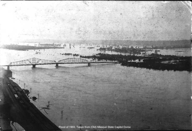
Looking Northwest from Dome of Old Missouri State Capitol in 1903
The floods of May and June 1903 were caused by unusually heavy precipitation events during the latter half of May. This flood was considered the most devastating since the settlement of the Kansas and lower Missouri River valleys. The same report referred to above, went on to state: "The floods of 1903 descended upon broad, fertile, and highly cultivated fields, and upon rich valleys filled to overflowing with vast industries devoted with never ceasing energy to the fulfillment of the insatiable demands of commerce... The number of human lives lost will never be accurately known, but the total reliable reported was exactly 100..."
1904
A sort of supplemental flood occurred in 1904, following that of 1903 in many particulars. Practically the same territory as was overflowed in Kansas City and Argentine during 1903 was again covered in July, 1904, to a depth of from one to ten feet. The population in this district prior to 1903 was more than 20,000; the sixth ward of Kansas City, Kan., known as Armourdale, had alone, prior to 1903, a population of more than 10,000. The overflow in Armourdale extended back from the Kansas river about a mile and a half, and submerged all the business portion and more than four-fifths of the residence district of the town to an average depth of about ten feet. Kansas, avenue is the main street in Armourdale, and its intersection with the Seventh street viaduct is about one mile west and north of the Kansas river. The conditions at this place, where the water was from five to six feet deep, are shown in several views.
1908
The flood in the Kaw and Missouri rivers in June, 1908, practically equaled that of 1904. Continuous and tremendous rains extended all over the middle West during the months of May and June. The flood of 1908 broke all records for duration. The Missouri rose above the danger line of 21 feet June 8, and on July 3 it was still at 25.4 feet. July 6 it fell to 20.6 feet. July 10 the water again reached 21.5 feet, and as late as July 16 it was 18.3 feet. Great rainfalls affected the Missouri its entire length, Montana and the Dakotas being flooded. Storms and heavy rainfalls prevailed in all parts of Kansas. The Vermilion in Marshall county was a mile wide June 5. Three feet of water was in the streets of Frankfort. June 5 a cloudburst in Wilson, Woodson and Greenwood counties gave a rise of thirty-eight feet in the Verdigris. A cloudburst in the Cottonwood and Neosho valleys gave Emporia a rise within a few inches of that of 1903. June 17, from three to five inches of rain fell in Gove County. On the 20th of June the water in the Solomon at Beloit stood 33.24 feet above the low-water mark, or 20 inches higher than 1903, washing away all the sheds in the Chautauqua park. In Sumner county, July 28, ten inches of water fell in five or six hours, drowning five people and wrecking thousands of dollars' worth of property. At Pleasanton, Linn County, June 29, 6.42 inches of rain fell. June 30, in Jefferson county, 4.15 inches came down, accompanied by the heaviest fall of hail known in twenty years. At Wichita, June 30 and July 1, there was a fall of 3.13 inches.
1951
The floods of June and July 1951 exceeded any others that had occurred in the lower Missouri River valley since the historic flood of 1844. A two-month period of above-normal precipitation followed by unprecedented intense rains over a 72-hour period in early July caused the resulting floods. The area most seriously affected was the Kansas basin and Missouri drainage below Kansas City, Missouri. The Weather Bureau Technical paper of this event states: "Industrial districts and transportation centers of three metropolitan areas, Kansas City, Kansas, Kansas City and St. Louis, Missouri, were in the path. Two state capitals, Topeka, Kansas, and Jefferson City, Missouri, experienced the devastation. In addition, 150 flourishing communities and smaller cities suffered severe damage. Thirty thousand farms, consisting of three million acres, were affected by the flood waters. Tangible losses amounted to nearly a billion dollars. Twenty-eight lives were lost. This flood, occurring in an important agricultural and industrial area, constituted a major national catastrophe."
1952
The floods of 1952 were caused by rapid melt of an above-normal snow cover in eastern Montana, North Dakota, and South Dakota. Record and near record flooding occurred on the Milk River, several tributaries to the Missouri River in North and South Dakota, James River, Big Sioux River, and the Missouri Mainstem. In a letter from Weather Bureau headquarters to then Hydrologist-In-Charge Ray Johnson, the following remarks of News Commentator Walter Cronkite were quoted: "In this record flood, only three lives have been lost so far -- and they only indirectly because of the floods. This remarkable safety record is a result of the Weather Bureau's river forecasting service -- a fantastic modern weapon against flood dangers. Headquarters receives reports of rainfall, the rapidity of melting snow and other factors -- and with a battery of modern gadgets, forecasts just how high the rivers will rise. From field observers, and headquarter offices such as that in Kansas City -- the Weather Bureau was able to forecast this historical flood as long as ten days before the crest reached Pierre, South Dakota -- first large population center to be hit."
1984
Large areas of the Missouri River basin received intermittent heavy rainstorms during the months of May and June 1984. Above average precipitation also occurred during the preceding months. The prolonged wet spring culminated with flooding in June. The flooding was the worst since the disastrous flooding in 1952. Numerous towns and riverfront developments were flooded or threatened with flooding. Many roads and bridges were washed out or damaged. Millions of acres of land were flooded or damaged by soil erosion. Thousands of acres of cropland were not planted because of the magnitude and timing of the flooding, causing a severe financial hardship for farmers. Combined, the rainfall and flooding caused hundreds of millions of dollars' worth of damage. The tributary river basins in which flooding or high flows occurred were the Beaverhead River and Ruby River basins in Montana; the Vermillion River, James River, and Big Sioux River basins in South Dakota; the Big Sioux River, Little Sioux River, and Nishnabotna River basins in Iowa; and the Salt Creek, Papillion Creek, Elkhorn River, and North Platte, and Platte River basins in Nebraska.
In addition to the major flooding that took place May-June 1984, three flash flood events occurred during June. The events occurred on June 9-10, 1984, along Indian Creek in Overland Park, Kansas, the Blue River in Kansas City, Missouri, and creeks in the St. Joseph, Missouri area. Another flash flood event occurred June 20, 1984, in the Belton, Missouri area taking one life.
1986
During September and early October 1986, extremely heavy rainfalls resulted in record flooding across Michigan, Illinois, Missouri, Kansas, and Oklahoma. In the MBRFC area of responsibility, some of the worst flooding occurred in and around the upper Osage River basin. Recorded rainfall data show that the maximum amounts of rainfall during the storms occurred in a band extending about 15 miles either side of a line from Truman Dam to Chanute, Kansas. Record flooding occurred along certain reaches of the Blackwater, Marais des Cygnes, Marmaton, Little Osage, Osage, Sac, South Grand and Missouri Rivers. The accumulation of runoff from the storms in the upper Osage River basin resulted in maximum daily inflows of record into Harry S. Truman Reservoir, Stockton Lake, and Pomme De Terre Lake Reservoir.
1993
An unusual combination and sequence of hydrometeorological events occurred in the spring and summer of 1993 which culminated in the widespread Midwest flooding known as The Great Flood of 1993. The flooding occurred as a result of a previous wet fall, normal to above-normal snow accumulation, rapid spring snowmelt accompanied by heavy spring rainfall, and heavy rains in June and July.
The Natural Disaster Report states: "The Great Flood of 1993 was an unprecedented hydrometeorological event since the United States started to provide weather services in the mid-1800's. In terms of precipitation amounts, record river stages, areal extent of flooding, persons displaced, crop and property damage, and flood duration, this event (or sequence of events) surpassed all floods in the United States during modern times... Within the Missouri River System, 1993 floods of record include those set at 14 forecasts points on the mainstem and at four forecast points on each of the Saline, Smoky Hill, and Grand Rivers. During the event, near flood of record stage occurred at an additional 23 forecast points on the Missouri River system alone. For example, in 1993, flood records set more than 42 years ago on the mainstem of the Missouri were broken by more than 4 feet at multiple forecast points. In at least one case, a new flood of record was established early in the event only to be broken by higher water later in the event..."
1995
During the spring of 1995, unseasonably warm temperatures in February and March resulted in snow melt which saturated the ground. This, along with repeated heavy rains in the Midwest during March, April, and May, produced significant flooding on many streams and rivers in the Dakotas, Nebraska, Iowa, Kansas, and Missouri, as well as other states. Initially most of the flooding was outside MBRFC's area of responsibility but by mid-April significant flooding occurred on the James and Big Sioux Rivers, and their tributaries. By mid-May widespread moderate to major flooding was occurring and thoughts of a repeat of "THE GREAT FLOOD" were going through people's minds. Most rivers, including the Missouri Mainstem, had crested by the end of May. Although flood records set in 1993 were approached, few were broken. Record high stages were set at various locations along the James River in South Dakota.
In addition to the major flooding that took place, flash flooding occurred May 7-10 in the Rapid City, South Dakota area. Keystone, South Dakota was evacuated. There were numerous road closures and bridges washed out in the Black Hills region of North and South Dakota.
As can be seen in the timeline of flooding of the Missouri River basin, the two decade period of time commencing in 1883 and ending with the flood of 1903 was one of frequent, devastating floods of frequency and severity unequalled in the recorded history of the Lower Missouri River. Completion of the Missouri-Pacific (Mo-Pac) Rail Line in 1855 and the Missouri-Kansas-Texas (KATY) Rail Line in 1895 and the resultant dying steamboat transportation industry were already causing major shifts in population centers away from the Missouri River waterway and landings to new communities located on and serviced by the railroads. The flooding occurred in the period 1883-1903 sounded the death knell of thse river communities which were so important to the steamboat industry of earlier years. The flooding forced those remaining residents of the area to pack their belongings and leave the river forever, bound for the commercial centers of the newly forming towns along the rail lines that follow the course of the river, further away from the destructive floods of the past.
 Chappell's Article on Flooding on the Missouri River |
The watershed of the Missouri river covers an area of 580,000 square miles, extending from New Mexico to the British possessions and westward to the Rocky Mountains. Within this vast expanse are thousands of streams which flow into the great river. Among the largest, beginning at the head, are the Tetón, Marias, Milk River, Yellowstone. Little Missouri, Knife river,
NOTE 1, -Mr. PHIL. E. CHAPPELL was born on the bank of the Missouri river, near Jefferson City, and for more than sixty years lived in sight of the river. During his early life he was engaged in Steamboating on the river; afterwards became a steamboat owner, and maintained his connection with the river as long as navigation continued. Mr. Chappell is the author of a paper published in the ninth volume of Kansas Historical Collections, pages 237-316. entitled "A History of the Missouri River." Mr. Chappell died in Kansas City, Mo.. February 23.1908. in his seventy-first year. For sketch of his life see volume 9. pages 237. 238.
NOTE 2.-These figures, and much of the following data have been obtained from the reports of the Missouri River Commission, and the writer takes occasion here to acknowledge his obligation to Mr. S. Waters Fox, who for many years wan engaged on Missouri river improvement work under that commission, for valuable assistance in the preparation of this paper.
Cannon Ball, Cheyenne, Owl river, White river, Niobrara, Dakota, Big Sioux, Platte, Nishnabotna, Nodaway, Little Platte, Kaw, Grand river, Chariton, Lamine, Osage, and Gasconade. Those flowing into the river above the Platte take their rise in the Rocky Mountains, while those debouching below that stream rise, with two or three exceptions, on the western plains.
The annual amount of precipitation within this vast watershed, all of which is carried off by the Missouri river, is almost beyond comprehension. The total annual discharge of the river has been estimated, from calculations made by the Missouri River Commission, at twenty cubic miles, or at a rate of 94,000 cubic feet per second.* Usually this vast volume of water passes off without doing any considerable damage, the banks of the river being sufficiently high to prevent an overflow. But occasionally an unusual fall of snow in the Rocky Mountains, or an extraordinary precipitation along the lower river and its tributaries, or both coming in conjunction, cause an overflow of the banks and the destructive floods that bring devastation, ruin and death.
To understand the cause of the floods in the Missouri it is necessary for one to understand something of the general contour of the river, its physical nature and its characteristic features. Formed by the confluence of three mountain streams the Jefferson, Gallatin and Madison it flows eastwardly, over numerous rapids, a clear, precipitous, rapid stream until well out of the mountains, after which it assumes a different character, first, as a sand bearer, and further on, through the flow of tributary streams and changes in bed-foundation, both a silt and sand bearer, until finally it becomes a pronounced type of an alluvial river.
From Sioux City, with an average slope of eighty-six one-hundredths of a foot to the mile, and an extreme variation on the gage of nearly nineteen feet at Sioux City and thirty-five feet from Kansas City to the mouth, the river flows on in a tortuous, divided and ever-shifting channel through a heterogeneous mass of sand and clay.
It is not to its tributaries that the Missouri owes the muddy character of its water to any great extent, for many of these, especially the smaller streams, are comparatively clear. Even the Osage and Gasconade, two of the largest, are perfectly clear, and their waters flow over pebbly bottoms. But it is from the character of the land through which it flows, the exceedingly fine, alluvial soil which is continually falling into the stream from the erosion of its banks as they become undermined by the swift current, that it assumes the dark, muddy color which characterizes it and from its first discovery has given it the name "Big Muddy." It was amusing in the days of steamboating on the river to observe with what reluctance the eastern traveler performed his ablutions in this muddy water. In pouring it into the basin he would step back in disgust and ask for some clean water, and, when told there was none, would simply wet the towel and wipe his face. One of these travelers said, after traveling for several days on the river, that " he felt as if there was a small sand-bar in his throat. ' ' No words could express more forcibly a caricature of the muddy water during a freshet.
But notwithstanding its muddy appearance the water of the river has been pronounced the most wholesome in the world ; the very sand held in solution serving to purify it and render it wholesome. And, when clarified Missouri River Commission. Annual reports. 1891. p. 3821; 1892. p. 3312. by settling, or in the winter, when it becomes clear, it is as pleasant to drink as that of any mountain stream. Several years ago a test was made in Paris, France, of waters taken from streams in different parts of the world, to ascertain which would continue pure and wholesome for the longest period of time, it being important that this fact should be ascertained for the benefit of the ships sailing on long voyages at sea. After a thorough test the water taken from the lower Mississippi which assumes its character from the Missouri was pronounced the purest and best.
Even the early Jesuit explorers recognized the excellence of the waters of the Missouri and lower Mississippi, which are the same, as will be seen from the following excerpt from a letter written at the old French village of Kaskaskie, near the present city of St. Louis, by Father Louis Vivier, on November 17, 1750. He says :
"Before its junction with that river [Missouri] the Mississippi is of no great size. Its current is slight, while the Missouri is wider, deeper, more rapid, and takes its rise much farther away. Several rivers of considerable size empty into the Mississippi, but the Missouri alone seems to pour into it more water than all these rivers together. Here is the proof of it: The water of most-I might say of all-of the rivers that fall into the Mississippi is only passably good, and that of several is positively unwholesome; that of the Mississippi itself, above its junction with the Missouri, is not of the best; on the contrary, that of the Missouri is the best water in the world. Now that the Mississippi, from its junction with the Missouri to the sea, becomes excellent, the water of the Missouri must therefore predominate.3
The elevation of the surface of the water in the river varies greatly in different years, and at different periods in the same year. For the purpose of preserving reliable statistics of the different stages of the water, the government, in 1888, established two grade lines from Sioux City to the mouth of the river, designating them respectively "standard high-water mark" and "standard low-water mark."
The former was determined from the highest known June flood previous to 1888, and the latter from the lowest known stage previous to that date. This data is not entirely reliable, of course, as previous to 1888 no accurate official records were kept. The difference in elevation of the two planes at Kansas City is 14.52 feet, and at St. Charles 16.13 feet. The general difference between high- and low-water mark at St. Joseph is 28 feet, and at Herman, Mo., the difference between the high-water mark of 1844 and the low-water mark of 1853 the highest and lowest stages known-is 32 feet.
Some idea of the effect of a flood on the volume of water discharged may be formed from the following comparison. The discharge at St. Charles at low standard stage of the water was estimated by the Missouri River Commission at 40,000 cubic feet per second; and at high water taken at the crest of the flood of 1892 - 650,000 cubic feet per second. The maximum discharge of the flood of 1903 far exceeded that of 1892, the estimated amount being the enormous quantity of 750,000 cubic feet per second.4 The velocity of the current in the river varies, of course, with the stage of the water. The ordinary velocity, at a low stage, is from two to three miles per hour. During floods, however, the velocity increases tremendously, frequently being as much as ten miles per hour. The river then becomes a raging torrent, its muddy surface covered with foam and driftwood and its waters whirling and boiling in every direction. Remarkable time was made downstream by steamboats on floods in the days of navigation on the river, twenty miles an hour being not unusual. At a still earlier period the keel- boats engaged in the fur trade always took advantage of the June rise in descending the river. In 1811 Manuel Lisa, the noted fur-trader and keel-boatman, sent a boat down from the Mandan village, where Bismarck, N. Dak., is now situated, to St. Louis, a distance of 1450 miles, in thirteen days, making an average run of more than 100 miles per day.5
NOTE 3. -Thwaite's Jesuit Relations, vol. 69. p. 207.
NOTE 4.-The above data have been obtained from the reporta of the Missouri River Communion.
The bed of the river above Carroll, Mont., is rocky, but below that point to Sioux City, is semi-alluvial. From Sioux City to the mouth it is full alluvial. This sand and clay, extending to bedrock, varies at different places from 40 to 100 feet. At St. Joseph, where borings were made by the Missouri River Commission, the rock bottom was struck 40 feet below the bed of the river, and the loose material above consisted of sand, gravel and boulders. At Randolph, just below Kansas City, 85 feet of sand and gravel were found and then 20 feet of boulders. At Boonville, from the bottom of the river to bed-rock, 55 feet of sand and gravel intervened. The bridge pier at St. Charles rests on solid rock at the north end, but in the middle of the river it was found necessary to sink a caisson 60 feet through sand to obtain a solid foundation.6 The deepest place in the river sounded by the government engineers is in Augusta bend, below Washington, Mo., where the water in an ordinary stage was found to be sixty feet deep. There are probably few deeper places in the river. The average depth, even in a high stage of water, does not exceed twenty-five or thirty feet, and the deepest water is always found in the bends, where, also, the strongest current is found. There was never any lack of water in the bends during the days of steamboating, even in a low stage; but there was found there a greater menace to navigation in the snags with which they abounded. Many of the bends of the river are twenty miles long and have been many years in forming. The banks of the river were originally lined with a primeval growth of large timber, and as they were undermined by the swift current the trees tumbled in and floated along until their roots became anchored in the bottom of the river. There they remained for years, becoming the "sawyers" that caused so many steamboat wrecks.
The "crossings," as the name indicates, are the places where the channel changed from one side of the river to the other. The water spreads out over a wide space at these localities, and, instead of there being one channel, there are frequently a half dozen chutes, neither of which, in a low stage of water, is deep enough to float a steamboat heavily loaded. Even on the crossings, however, in an ordinary stage, there was sufficient water for a boat to pass through without running aground.
NOTE 5.-Bradbury's Travels, pp. 182-197.
NOTE 6.- Chief of Engineers. U. S. A., Annual Report. 1890. pt. 4. p. 3376.
In the days of steamboating on the river navigation began on the breaking up of the ice, usually the last of February or the first of March, and continued until the ice began to run in the following November. During this period there was usually sufficient water for boats drawing six feet until after the subsidence of the June rise in August. From that time the river declined rapidly, until during the latter part of the season it was difficult to find more than three or four feet on the crossings.7 When the water receded to this stage it was the custom to withdraw the larger boats and put them in the lower Mississippi, leaving only the light draught vessels to continue in the trade.
It is the consensus of opinion among all old steamboat men now living that there is as much water in the river today as there ever was, and that it could be as easily and safely navigated. Indeed, there are reasons for believing that the river is a safer stream and could be more easily navigated than formerly, when it was crowded with steamboats, as the land along the banks has been put in cultivation, the trees have been cut down, and there are fewer now to fall into the river and obstruct navigation; besides, in many of the worst places, especially in the lower reaches, the government has so improved the channel of the river, by a system of revetments and dikes, as to strengthen and deepen it. thereby increasing its navigability. The work that has been done, much of which has stood the test of twenty years, only shows what vast improvement could be made in the river by a systematic and persistent effort under the modern and skilful methods of engineering.
An experienced riverman can always determine, when looking at a river during a flood, whether it is rising or falling. When rising the surface of the water becomes convex, and, being higher in the middle, the driftwood flows to the sides. Vice versa, when the river is falling the surface becomes concave, and the driftwood then flows to the middle, leaving the sides next to the shores clear. It has been said that during a flood the surface of the water varies as much as two feet between the middle of the river and the shore line.8
The excessively uneven condition of the bed of the river, and the continual caving in and cutting away of the higher portions, called "reefs," produces a whirling and eddying of the surface of the water which enables the pilot to judge approximately the depth of the water and determine where the channel is. Standing at the wheel he can look ahead a hundred yards, and from the ripples on the surface and the boils and whirlpools determine when the bluff bar at the bottom of the river is cutting away and what changes are taking place below. This is called by rivermen "reading the river," and it is wonderful how expert some of the pilots became in old times in thus fathoming the unseen mysteries of the river.
The upper portion of the Missouri is subject to a flood peculiar to that part of the river. There, the winters being exceedingly long and cold, the ice freezes to unusual thickness. When it breaks up in the spring it floats down in unusual floes, until, on arriving at some narrow place, it becomes gorged and effectually dams the current. This causes an overflow of the bottom-lands, which, coming so quickly and without warning, results in great damage. The ice in these gorges piles up, one floe on top of another, to a tremendous height, developing a power that nothing can withstand. Finally the pressure of the current of the river, combined with the ice, accumulates a force sufficient to break through the dam, and it gives away with a report that can be heard for miles. The breaking of such a gorge is one of the most sublime and awe-inspiring sights in nature.9
NOTE 7.-On one occasion the writer undertook to take a steamboat down the river at St. Louis in November, and notwithstanding she was exceedingly light, and did not draw over three feet, it was impossible to find sufficient water on the crossings to get through.
NOTE 8.-Brackenridge's Journal, pp. 45. 96.
NOTE 9. -For further description of an ice-gorge on the upper Missouri, see Chittenden'e Early Steamboat Navigation on the Missouri, vol. 1. p. 82.
Occasionally, in looking out on the river, even as low down as Kansas City, on a warm and pleasant day in spring, one sees the surface of the water covered with thick floating ice. It is a strange phenomenon, and the onlooker, if a stranger, will wonder where this ice came from. It is from one of these upper-river gorges, and has probably floated a thousand miles, the water not having yet become sufficiently warm to melt it. This ice, which is exceedingly thick and clear, frequently floats down the river as far as Jefferson City, and the writer has seen the ice-houses at that place filled with it as late as April.
There are many places along the lower river10 where creeks come through the bluffs at points where the bottom is not more than a mile wide. Naturally, the land always being lower near the bluff, the creek flows along down the bluff until finally, after several miles, it makes its way across the bottom to the river. In the course of time the river, in its unrestrained and destructive course, cuts away the bottom at the upper point until it finally reaches the creek at the place it comes through the hills. When this occurs, following the laws of gravitation, the creek seeks a new channel, and debouches into the river at the upper point. There are many such places as have been described -along the river. There is one opposite Jefferson City, one below Brunswick, Mo., and one at Langdons, above St. Joseph. The old beds of the creek become sloughs and furnish most excellent fishing grounds.
Above the mouth of the Platte, the country being prairie, the bends assume a more decided curvature than below, many of them being in the shape of a horseshoe. The largest of these, known as the Great Bend, is thirty miles around, while the distance across the neck is but little more than a mile. Steamboat passengers were accustomed, in ascending the river, to disembark at the lower end of the bend, and, after spending a day in hunting, catch the boat at the upper end. A similar bend was one above Onawa, Iowa. This bend was twelve miles around, while the distance across at the narrowest point was only about fifty rods. In the course of time the swift current of the river, in its constant and never-ceasing erosions, cuts away the bank on the upper side of the bend until it finally eats its way through the narrow neck to the opposite side. The surface of the river being lower there the water rushes through with tremendous velocity carrying everything before it in its mad sweep. The result is that a new channel, called a ' ' cut-off, ' ' is formed, and the bight of the bend is left an island. These changes in the channel of the river have been the cause of endless litigation in the ownership and jurisdiction of land involved, especially when the river is the dividing line between two states.11
NOTE 10.-The mouth of the Platte was always considered among rivermen the dividing line between the upper and lower river. This place was regarded by the early fur-traders of the Missouri as "a point of as much importance as the equinoctial line among mariners. All those who had not passed it before were required to be shaved, unless they could compromise the matter by a treat." It was generally the scene of much merriment. -Brackenridge's Journal, 1816, p. 79.
NOTE 11-Chittenden's Early Navigation on the Missouri River, vol. 1. pp. 77-79.
Many years ago a steamboat, in ascending the upper river, was passingaround one of these bends, when she met with a very strange accident. She made a landing in the bight of the bend and passed on up-stream. Imagine the astonishment of the people at the landing when, in looking downstream, several hours afterward, they saw the same identical steamboat coming up-stream again. They could scarcely believe their eyes; but there could be no mistake about it. The explanation illustrates one of the strange freaks of the river. Unfortunately, just as the boat was passing the narrow strip of land constituting the heel of the horseshoe, and while running close to shore, the current broke through the narrow strip and formed a cut-off. The water rushed through the new channel with such tremendous velocity as to sweep the boat along with it. The current was too strong to stem it in returning, so that she was compelled to go around the old channel, the way she had gone up several hours before.
The channel of the Missouri river may be compared to a great cradle or trough. On.either side are parallel bluffs which seem to have been placed there by nature to confine its turbulent waters within certain bounds. The distance between the bluffs varies, causing the intervening bottoms to become much wider at some places than others. At Yankton, S. Dakota, the bottom is three miles wide, at Omaha five miles wide, and at Kansas City about two miles in width. Between Kansas City and Boonville the bottoms become wider, reaching a maximum of eight or nine miles at Wakenda, near Carrollton, where it is wider than at any other place on the river. From Boonville to the mouth of the river the width becomes more uniform, the average being about two miles.
This vast bottom, extending from Sioux City to the mouth of the river, a distance of 800 miles, is as rich as the valley of the Nile. It is composed, as has been stated, of a mixture of sand and clay, held in minute particles, forming a loose alluvial soil. It is easily undermined by the action of the water, but held in suspension in a current of moderate velocity. Through this bottom the river meanders on its way to the Mississippi, its channel remaining constant only where it hugs the rocky bluffs. In its intermediate wanderings the channel varies constantly, following a zigzag course from one side of the river to the other, and often flowing to every point of the compass within the distance of a few miles.
The width of the river from bank to bank, at its normal stage, varies at different points, but gradually becomes wider as it approaches the mouth. Standard high-water widths adopted by the Missouri River Commission are: From Sioux City to the mouth of the Platte, average width, 820 feet; from the Platte to the mouth of the Kaw, 960 feet, and from the Kaw to the mouth of the Gasconade, 1160 feet. From there to the mouth the distance becomes greater, averaging 1240 feet wide.12
One would naturally suppose, in looking at the Missouri river, that at some time in the distant past the bed of the stream extended from bluff to bluff. The precipitous contour of the rocky bluffs suggests such a thought. But a moment's reflection would controvert this impression, for the laws of nature never change and the river drains the same watershed today that it did at the creation of the world. The bottoms, which generally extend over three-fourths the distance from one bluff to the other, are "made land," caused from the accretions of centuries, and furnish a leeway for the channel of the river. They may have been thousands of years in forming, but sooner or later the channel, unless restrained, will go back and claim its own. When the channel of the river changes it leaves a sandbar, which soon becomes overgrown with willows and cottonwood. These catch and retain the silt and sand deposits of subsequent overflows, which, continually raises the surface of the accretion, until, finally, together with decaying vegetation, it becomes as high as the adjacent land. This process goes on for centuries, and in this manner the bottom lands along the river are continually forming and reforming. Surveys made along the lower river during the French and Spanish occupancy, and even during the early part of the last century, substantiate the correctness of this theory, but if further proof be required, let a hole be bored down anywhere in the river-bottom, and at a distance of twenty-five feet, or when the level of the water in the river is reached, a flow of water will be found, and probably a wrack-heap, or an old log, proving conclusively that the channel of the river at one time flowed there.13
NOTE 12.-Letter from Missouri River Commission. July 3. 1908.
NOTE 13.-The writer has before him a map of the land in Galloway county. Missouri, where he formerly lived, made by a government surveyor in 1818. when that section was first surveyed. There is laid down on the map a sand-bar fronting the river, which was considered of so little "value then that it was marked " sand-bar." and was not surveyed. When a small boy. this sandbar was thickly overgrown with cottonwood. He has seen these trees grow to be four feet in diameter, cut down and sawed into lumber, and the land put into cultivation. It is now worth $100 per acre, and the present value illustrates the wonderful changes that have taken place in many localities along the Missouri river within the period of a single lifetime.
The Missouri river is the most erratic stream in the world, and is as fickle in its notions as an old bachelor. It goes zigzagging along until, without any apparent cause, it becomes dissatisfied with its bed and cuts across to the opposite bluff to find a new channel. The old bed in the course of time becomes filled up with a sandbar and overgrown with an arboreal growth of willow and cottonwood. Then, in a few years, the river, again becoming restless and dissatisfied, goes back to its original bed. In the days of steamboating this continual shifting of the channel was the most formidable obstacle to navigation and the most serious difficulty the pilot had to contend with. The river had to be "learned over" again every year, if not every week. On the return of a steamboat from a voyage up the river, even after a few days, the channel would frequently be found on the opposite side of the river. It was the custom of the pilots to have a mail-box at every landing, and the ascending or descending pilot would drop a letter in the box notifying his brother pilots of any change in the channel in the reach over which he had passed. The notice would probably read about as follows:
"Look out for a change at Horsetail bar. The upper chute has cut away the bluff-bar at the foot of the tow-head, and the crossing is now a half mile lower down, opposite the cabin in the bight of the bend."
Such a warning would be sufficient, for the pilot knew the river as the schoolboy knows the path to the schoolhouse. He was supposed to know the location of every sand-bar, snag, wreck, chute and cut-off, and the situation of every wood-chopper's cabin along the shore. Such was his familiarity with the stream that he knew every crook and turn of the channel, and no night ever became so dark as to cause him to tie up his boat, especially in running upstream.
No other river in the world has such a voracious appetite as the Missouri. It is constantly swallowing up farms along its banks, and it is not unusual for a farm of a hundred acres to be engulfed in a single season. In its wild freaks, when it cuts across in search of a new channel, the current strikes the alluvial soil with such velocity that it undermines it, and it melts away as a snow-bank before the noonday sun. The substratum of the land being composed of sand, great chunks tumble into the water, causing a splashing noise that can be heard for a mile. There is nothing so well calculated to disturb the slumbers of the owner of a farm thus encroached upon as this continual booming noise, admonishing him that the hungry river is banqueting on his land, and that it is being swallowed up, acre by acre, with no power to arrest the destruction.
It is during the spring floods that the greatest damage is done by the erosion of the river. After the water has receded, and is well within the banks, all danger is over for another year. It has been estimated that not less than eleven billion cubic feet of soil are annually washed out by the Missouri river, and not less than 400 million tons of earth are carried away in solution.14 This immense quantity of sand, silt and clay is conveyed into the Mississippi and thence on down to the Gulf of Mexico. It was this deposit at the mouth of the river which proved so great an obstacle to navigation until removed by the construction of the Eads jetties.
It is believed by geologists that the entire Gulf coastal plains, including the state of Louisiana, have been formed from alluvial deposits from the Mississippi, most of it, of course, having come out of the Missouri. This opinion seems plausible from the topography of the country and from the fuct that the entire delta of the great river is composed of sand and silt, not a single rock being found from Natchez to Balize. The great accretion at the mouth of the river has doubtless been accumulating since the creation of the world, and this is one of the strongest reasons for the belief entertained by many that the earth is much older than it is supposed to be from Biblical account.
The river robs Peter to pay Paul, for as an acre of land is taken off at one place by erosion, another is deposited somewhere else. This is a wise provision of nature, for otherwise the entire bottoms would soon be swept away. It is true that it requires many years for the accretion to become sufficiently high for cultivation, but the process of building up heretofore described goes on from year to year, until eventually the newly made land becomes fit for the plow and as valuable as that which was washed away.
Naturally the uncertainty of the permanency of the channel of the river has a tendency to depreciate the value of the land along the banks and render the tenure of ownership uncertain. A farmer may plant a field of corn along the bank of the river; but if a field should happen to lie in a bend he has no assurance that either the crop or the land will be there at harvest time. In many places in the bottoms the railroads parallel the river, and in protecting their roadbeds from erosion, by riprapping and dikes, they protect the adjacent land. Fortunate indeed is the man who has a railroad between his farm and the river, for there is a vast difference between the value of the land on the inside and outside of the track, the one being permanently protected while the other is in constant danger of being washed away.
NOTE 14.- Letter of Missouri River Commission. July 3. 1908.
In the lower part of the river, where the Missouri River Commission did work several years ago for the purpose of controlling the channel, not only has the sapping of the banks been completely arrested, but thousands of acres of rich lands have been restored and created. In the reach extending from Murray's Bend, above Jefferson City, to the mouth of the Gasconade, a distance of fifty miles, may be seen the result of modern scientific methods of river improvement by means of revetments, dikes and mattresses. The channel of the river has not only been confined and straightened, but bends have been filled up, and where the water formerly spread all over the river bottom is now a fixed channel, which scours itself to the depth of six feet at the lowest stage.* These improvements demonstrate what can be done towards making the Missouri river a first-class navigable stream. It only requires the expenditure of a sufficient amount of money, in a systematic manner, under the direction of a corps of skilful engineers. It is no longer an experiment. Of course it is not the province of the government to protect private property, but if, in improving the river and making it the great commercial thoroughfare between the East and the West it is destined to become the rich alluvial bottoms along its shores should be incidentally protected, certainly it is a greater reason why the work should be done.
* E. F. C. Harding, city engineer of Jefferson City. Mo., replying to an inquiry, writes under date of July 13. 1908 : "The dykes and revetment work were never kept in good repair, and the greater portion of it has gone to ruin and washed out. Fronting Jefferson City, for instance, if the entire Missouri river had been put in the ???? condition. 1 venture to say the channel would be from nine to ten feet at its lowest stages. Where the river once was 4500 feet wide, it now is 1300 to 1600 feet."
The writer once owned a valuable farm of several hundred acres in a bottom which was situated in a bend of the river. His title extended back to the government, and the patent described the land by section, township and range. Any surveyor can find the land from the description, for it is there today ; but alas ! it has changed owners, notwithstanding the fact that the writer never made a conveyance of his title. It was foreclosed under a mortgage held by the Missouri river, and the farm now lies on the opposite side of the river, and in a different county. It now belongs, under the law of accretion, to the owner of the land on that side, which it adjoins.
But the writer owns another river-bottom farm, which he has owned for many years, which fortunately is not located in a bend, and to this one has been added by accretion almost as many acres as were lost by the one swept away. It is situated about ten miles below where the former one was, and, as some measure of recompense, the rich soil taken from the upper farm has been added to the one lower down. The latter is protected by dikes constructed by the Missouri River Commission, and is part of a tract of 3000 acres extending up and down the river ten miles by a half mile wide. This " made land, " which has been permanently protected and restored to the original owners, is much of it in cultivation, and is as valuable as any in the bottoms. The history of these farms and there are hundreds of similar cases all along the bottoms, illustrates the capricious course of what may properly be called the "Robber river."
The propensity of the river to dabble in real estate and upset titles has been the cause of endless litigation, and many conflicting decisions by the courts bearing on the rights of riparian landowners. A case decided by the supreme court of Missouri several years ago illustrates the peculiarity and apparent injustice of the law. A. owned a farm fronting on the river, and his neighbor B. one directly back of it. A.'s farm was washed away, and B.'s farm became the bank of the river. In a few years, by a freak of the river, the land again filled in, and what had been A. 's farm was restored to its original dimensions. It would seem that in equity A. was entitled to his restored land, but the court held differently, and under its decision the title to the newly made land was vested in B. Had there remained, however, but a single strip of A. 's land not more than a rod wide, the decision would have been different, and he would have been given title to the restored land and all accretions thereto.
The soil of the river-bottoms varies at different places along the river from forty to more than a hundred feet in depth. From borings made by the River Commission the following data have been obtained : At Sioux City the distance from the surface of the ground to bed-rock was found to be 100 feet, and at Omaha 110 feet. At Leavenworth the soil was found to be only 40 feet deep, whereas at Kansas City, Mo., the borings showed a depth of 80 feet. These borings confirm a fact known to every one who has dug a well in the river-bottom; that is, that the soil varies in composition at different depths, there being first a strata of sand, then one of clay, then another of sand, etc., and that they alternate until water is reached. In boring for wells in the bottoms it is well known that if water be reached in a bed of white sand it is as clear and limpid as if it had passed through a filter, which, as a matter of fact, it has. But if the flow is found in a bed of blue clay, as is frequently the case, indicating the presence of an old wrack-heap, it is discolored and scarcely palatable. These different strata of clay and sand, alternating as they do, is another proof of the theory which has been advanced as to the manner in which the bottoms have been formed- that is, by gradual accretions.
The land in the river-bottoms is always lower near the bluff than it is on the bank of the river. It is also of a different formation, being clay, while that near the river is invariably sandy. The channel, as it gradually recedes from the bluffs, leaves sloughs, which are parallel with each other, and between these sloughs is high ground, also parallel, called "benches." These sloughs are subject to overflow whenever the river gets beyond the danger line, and it is in these low places that the damage occurs from an ordinary overflow. There is some compensation, however, as the deposit of silt left greatly enhances the soil. The land on the benches, being sandy and loose, is easily cultivated, while that in the sloughs is tough and difficult to plow. The latter, however, is stronger, and when it escapes an overflow is more productive than the higher land. On the first settlement of the river-bottoms the land, under the bluffs, being low, was wet and swampy from the surface- water which came down from the hills. There was no outlet to these sloughs, hence the water remained in them most of the year. It was this stagnant water which produced the chills and fever which so greatly prejudiced the pioneer against the river-bottoms. In recent years these lands have been to a great extent drained, and are now the most productive in the bottoms.
One of the most disastrous results that follows a general flood, when the bottom is submerged from bluff to bluff, is the condition in which the surface of the land is left. In many places a deposit of white sand remains, which greatly injures the land for many years. Sometimes this sand is left in high knolls, and again the entire surface of the ground is covered with a stratum a foot deep. At other places, where the surface of the ground was originally sandy and loose, great gullies are washed out, the soil having been scooped out by the swift current. At still other places, where the current is obstructed by some object which breaks its force, a deposit of silt is left which benefits the land.15 It is difficult to account for these strange freaks of the river, for the facts seem to be that when the current becomes obstructed from any cause, and its force broken, a deposit is left, sometimes of sand and at others of silt, whereas, when unobstructed, its great force not only prevents a deposit, but where the surface is loose scoops out great gullies.
Every one familiar with the Missouri river has observed crescent-shaped lakes in the bottoms, some of which (such as Creve Coeur lake, opposite St. Charles; Cooley lake, near Kansas City; Lake Contrary, near St. Joseph; and Bean lake, below Atchison) have become noted fishing and pleasure resorts. These lakes are evidently formed in the following manner: The river, in its unrestrained rambles from bluff to bluff, performs some curious freaks. It sometimes abandons one side, which it has followed for many miles, and, without apparent cause, jumps over to the opposite side, a mile or two away. Where it thus abandons its old channel it leaves a depression, or basin, the ends of which in the course of time become filled up as high as the adjacent land. The basin thus left becomes filled from surface-water, or from creeks flowing into it, and thus these beautiful lakes are formed. They are simply the former bed of the river."
There have been three great floods in the Missouri river since it was first known by the French explorers, the floods of 1785, 1844 and 1903, and it is a strange coincidence, and worthy of notice, that these floods have occurred just fifty-nine years apart. But that there have been other floods, far greater than those of which we know, and antedating them hundreds of years perhaps, is evident to any one familiar with the physical characteristics and topography of the river-bottoms. In many places in the bottoms, especially below the mouth of the Kaw, are high spots or knolls, which were not submerged by either the floods of 1844 or 1903. These high points, which are sometimes in the shape of benches, are composed almost entirely of white sand, rendering the land of but little value for cultivation. They are composed of exactly the same material as are the sand-bars in the river, and, being higher than the surrounding bottom-lands, must evidently have been deposited there by some great flood of which nothing is now known, even through tradition.
Having described some of the most striking characteristics of the Missouri river and the valley through which it flows, and in my former paper having shown the impression its turbulence produced in the minds of the explorers who first saw it, we come now to the floods in the river as their history has been preserved in tradition and in the official records of the government, supplemented by the personal observation and recollection of the writer, who has lived on its banks or been connected with its navigation for more than half a century.
NOTE 15.-The writer owns a farm of several hundred acres in the river-bottom which, in 1903. was entirely submerged to the depth of from three to six feet. It was planted in wheat and corn that year, and the fields laid aide by aide. Where the wheat stood was left a deposit of silt, probably six inches deep all over the field, but where the corn was planted the ground was left bare, even the loose soil having been washed away. The wheat, then in head, had evidently broken the force of the current sufficiently to leave a deposit of silt, while the corn, being only a few inches high, had presented no obstacle to its velocity.
NOTE 16.- Chittenden's Navigation of the Missouri River, vol. 1. p. 79.
There are two annual floods in the Missouri river, each of which occurs with remarkable regularity, one in April and the other in June. Both are destructive to property and greatly disturb the channel of the river by the erosion of its banks. The April flood, which is caused solely by unusual spring rains on the lower river and its tributaries, is sharp and sometimes destructive, but is of short duration, and generally subsides before the June rise from the mountains arrives. The water during this flood frequently exceeds the danger line, and flows into the sloughs and inundates the low bottoms, thereby destroying the crops; but as this occurs early in the season there is generally time to replant. Never in but one year, 1881, since the country was settled has the April flood reached to such a height as to cause much damage to the bottoms.
The June flood is caused primarily by the melting of the snow in the Rocky Mountains, but has never, with the exception of the year 1881, when it arrived two months ahead of time, proved dangerous, unless supplemented by an excessive precipitation in the lower portion of the valley. It is true that the water in the lower river sometimes reaches the danger line and flows into the low places without being augmented by heavy rainfalls in the lower watershed, but these overflows are not of much importance and cause but little loss of property. It is when the heavens let loose their flood-gates, and the downpour continues almost incessantly for weeks, as it did in 1844 and 1903, that the great exceptional floods occur that inundate the bottoms from bluff to bluff, bringing devastation and ruin in their wake. Fortunately this conjunction of waters, coming from entirely different sources, has in the past only occurred after the lapse of long periods, else the Missouri river bottom-lands would not be reckoned, as they are, among the most valuable in the world. Nor should the infrequency of the great floods lead to the delusive hope that they will never occur again, for the same conditions which prevailed when they did occur may come again and would inevitably bring about like results. This fact may not be pleasant to contemplate, but it must continually confront the inhabitants of the bottoms as a menace.
Between 1700 and 1720 the old French villages of Cahokia and Kaskaskia, and Fort Charles, just below the mouth of the Missouri, were established.17 They were the first settlements made on the Mississippi above New Orleans, arid antedated the permanent settlements on the Missouri more than half a century, St. Charles, on the Missouri, having been settled in 1769. Hence we must look to the archives of these old villages for information as to the floods in the Missouri river during the eighteenth century.
The first flood of which there is any record occurred in 1724. Among the ancient archives of Kaskaskia has been found a petition from the residents to the king of France for a grant of land. The petition was forwarded in the year 1726, and in it is stated the fact of a flood in the previous year, in which great damage was sustained by the inhabitants. The villagers were driven to the bluff ; their gardens and corn-fields were destroyed ; and the Great American bottom, opposite the present city of St. Louis, entirely submerged. There is no record of the actual stage of the water nor of the date of the flood, but it probably occurred in June, and doubtless came out of the Missouri, the source from which all floods in the lower Mississippi principally come.
NOTE 17.-See Spears and Clark's History of the Mississippi Valley, p. 69; Opening of the Mississippi River. F. ?. ???. P. 219: 111. Hist. Library Pubs. No. 10, p. 138.
There was a tradition among the old French people of these villages that there was an unusually high rise in the river between 1740 and 1750, but no reliable reference has been found of it in any history of the river. There is no doubt that if such a flood did occur it came out of the Missouri. In the year 1772 another flood occurred, which inundated the villages and caused Fort Charles to be abandoned and the English troops stationed there to be removed to Kaskaskia. But, like the previous floods, owing to the sparsely settled condition of the country, no particulars referring to it have been preserved.
The next period of extreme high water at the mouth of the Missouri-a flood which, for the reasons given, it is believed came out of that stream - was in 1785. During that flood, the American bottom and the lowlands around the old French villages were again submerged. Like its predecessor, we have but meager data relating to this flood; but from the information we have it may be classed with the great floods of 1844 and 1903, and came out of the Missouri river. It is spoken of as the greatest overflow of the eighteenth century.l8
Gen. Firmin A. Rozier, whom the writer knew personally in his youth, was a splendid type of the original French settler of the Mississippi valley. He was a native of the old French village of St. Geneviève, and I gather from his History of the Mississippi Valley, 1890, pp. 42 and 97, the following regarding the flood of 1785:
The old town of St. Geneviève was abandoned in 1785 ( there was an old and a new town) on account of the great flood of that year, known among the inhabitants as "l'année des grandes eaux," which destroyed all the settlements in the lowlands of the valley in its mighty sweep to the gulf. The inhabitants of Cahokia, Kaskaskia and Fort Chartres fled from their homes on account of the flood and sought safety elsewhere. The overflow of that year has never been equaled, for the entire valley was one vast sea from bluff to bluff, and presented a sight never forgotten by those to whom it brought destruction and ruin. In 1844 it was contended by some of the oldest inhabitants of the French villages, who remembered the flood of 1785, that the water attained a greater height that year than it did in 1844. But it has been pretty well established by high-water marks of 1785, regarded as reliable, that the 1844 flood was 2.4 feet higher than that of 1785. The destruction of property in 1785, even at these old French villages, was comparatively light, owing to the few inhabitants, and the loss on the Missouri river is not to be considered, as there were no settlements on that river above St. Charles. That mighty stream then spread over a wilderness, uninhabited save by wild beasts and savages, and there was nothing to destroy in its wild sweep.20
NOTE 18,- I am much indebted for information regarding the early floods in the Missouri valley to the publication of the United States Weather Bureau entitled " Flood of the Spring of 1903 in the Mississippi Watershed," and known as " Bulletin M." See p. 42. NOTE 19.-Publications of the Historical Library of Illinois. No. 10. p. 188.
NOTE 20. -"The flood of 1785 was one of the severest in the history of the Mississippi. The water extended to the bluffs on both sides. The people of Cahokia and Kaskaskia were obliged to seek shelter on the higher ground. At Kaskaskia many houses were swept away. The western bank suffered no less severely, and the old village of Ste. Geneviève was deserted for a site more protected from the river."-Dodge to Wm. Clark, October IS, 1785. Dr. MSS. lM126.-Collections of the Illinois State Historical Library, vol. II. p. 202.
While there were doubtless other years of high water on the Missouri river subsequent to 1785, we have no account of them until 1811. This was a memorable year in Louisiana territory, which then embraced what is now the state of Missouri, for the occurrence of three unusual events-the appearance of a great comet, the New Madrid earthquake and a great flood in the Missouri river.-' Fortunately we have a record of this flood, in the journal of H. M. Brackenridge, the English traveler, who in that year ascended the river with Manuel Lisa in a keel-boat, to the Mandan village, near where Bismarck, N. Dakota, is now located, setting out on April 2, 1811, and returning to St. Louis early in the following August.
There were then but few settlements on the river, the country having only recently come into the possession of the United States. There was the village of St. Charles, near, the mouth of the river, settled by the French in 1769, and twenty-five miles above, the French-American settlement of Femme Osage,22 the first home of Daniel Boone in Missouri. It was also the home of Boone's sons and many other noted pioneers, among whom was Ira P. Nash,* the first Anglo-American to ascend the Missouri river, he having preceded Lewis and Clark several months. Boone later made his home with his son-in-law, Flanders Callaway, near LaCharette. His grandson, Capt. James Callaway, was killed by the Sac and Fox Indians, near Loutre island, on March 7, 1815.
* " In regard to Ira P. Nash. I cannot give you any authority for the statement that he ascended the Missouri river prior to the Lewis and Clark expedition. In 1798 he was employed at a Spanish fort on the Missouri, and received a grant of ]and on this river in what is now Howard county, and lived there in 1801. One H. Nash was deputy surveyor here between 1799 and 1803."-Letter from I. Head, librarian Missouri Historical Society. St. Louis, July -IB, 1908.
A little further up, on the north side of the river, was the French village of Charette, and still higher, opposite the present town of Herman, Mo., a small American settlement, called by the French "Isle a la Loutre" (Otter island ) and by the Americans Loutre island. Nearly opposite the mouth of the Osage was the village of Cote sans Dessein, - which was settled in 1808, and in 1811 contained sixteen families, thirteen of whom were French and three Indian. There was no other settlement above, except that at Boone's Lick, four miles from Franklin, which was settled in 1810 by Colonel Cooper and a colony of Kentuckians.
It will be seen that there were but few inhabitants along the river in 1811, and as they were mostly hunters, depending on the chase and not agriculture for sustenance, there was but little land in cultivation, hence the damage done by the flood of that year was inconsiderable. The greatest misfortune caused by the flood was the unusual and protracted season of sickness which followed the subsidence of the waters. It was probably never exceeded in the bottoms, except by the sickness which followed the flood of 1844, and only in the case of the latter year from the fact that the country was more thickly populated. The great amount of sickness in 1811, called by the early pioneers the " year of the waters, " caused the temporary abandonment of the settlement at Boone's Lick and the removal of the colonists down the river to Loutre island, where they remained until the spring of 1812.-J
NOTE 21. -Early Western Travels, vol. 26. p. 63; Scharf's History of St. Louis. 1883, vol. I. p. 210; vol. 2. p. 1062.
NOTE 22. - This village, or settlement, was situated on the Femme Osapre creek, so called from the fact that the body of an Osage Indian woman was found in the creek at an early day.- See Switzler's Commonwealth of Missouri.
NOTE 23.-Brackenridge's Journal, p. 30; Long's Expedition, 1823, vol. 1, p. 74.
As usual, there were two freshets in the river in 1811. Brackenridge states that when he left the mouth of the river, on April 2, the flood of March, which immediately succeeds the breaking up of the ice, had begun to subside, yet the water was still high. Only an ordinary stage of water was met until about May 13, when the June rise was met above Council Bluffs, and the voyagers found driftwood descending in great quantities. On the return trip-the last of July-they found the bottoms almost everywhere overflowed below the Omaha Indian village (near Omaha), and were obliged at times to encamp on wrack-heaps in the river. Still lower down, about the mouth of the Platte, the traveler says: "The low grounds were everywhere inundated. The water rushed into the woods with great velocity, and in bends it poured over the gorge into the river again; a sheet of water, sometimes for a mile, flowed over the banks, forming singular cascades of eighteen inches in height."25 General Rozier, in describing the flood of 1811, says:26 "During the summer of 1811 the waters of the Mississippi rose to an unprecedented height, overflowing all low-lying lands and occasioned great distress to the inhabitants of Ste. Geneviève, Kaskaskia and the settlements in the bottoms. . . . Indeed, this overflow was only exceeded by the great deluge of 1844."
From the foregoing description one might be led to infer that the flood of 1811 was of unusual height and should be classed with those of 1844 and 1903, but such is not the fact, for while, undoubtedly, a great flood, probably the greatest between 1785 and 1844, there is no evidence that it extended from bluff to bluff; hence it cannot be classed with the great floods of the river. In the "Review of the Floods in the St. Louis District," that of 1823 appears to have been due to the watershed oí the Missouri, and although conditions in the Missouri bottoms is not alluded to it must have been severe, as the dwellers in the American bottoms in Illinois, the old French villages and East St. Louis were obliged to flee to the high grounds. The duration of the flood was from May 8 to 23. It was caused by the heavy snowfall throughout the Northwest and heavy rains.
No other flood occurred in the Missouri river worthy of notice until 1826 27 The spring of that year was unusually wet, and tremendous rains fell along the upper basin of the river. The river commenced rising about the middle of April, and towards the last of May had overflowed its banks from the Kaw down, and spread all over the low places in the bottom.28 This was another instance of an April flood being augmented by the annual June rise, with the usual result, an overflow. By the 10th of June the flood had reached its crest and begun to decline. The damage done was not great, for as yet there were but few inhabitants in the river-bottoms and but little land in cultivation. There is but little reliable material to be obtained of the flood of 1826, but from what is now known it seems to have been about such a flood as that of 1811, neither of which inundated the entire river-bottom except in what is termed the ' ' low bottoms, ' ' the definition of which will hereafter be given. It is not believed that either of these floods reached the high-water mark of 1844 by from six to eight feet.* In the report of the chief engineer of the government, in 1872, page 429, it is estimated that the height of the water at St. Louis during the flood of 1826 corresponded to a stage of 33.81 feet on the present gage at that place. This estimate corresponds closely with the traditional comparison of the heights of the floods of 1826 and 1844.
NOTE 24.-It is probable that the frequent attacks by the Indians had something to do with this retrograde movement, for this was just the beginning of the War of 1812. and the Indiana were troublesome all atonte the frontier.
.NOTE 25.-Brackenridtre, pp. 8, 202.
NOTE 26.-History of the Mississippi Valley, pp. 318, 319.
NOTE 27.- "During: 1826 there were tremendous rainfalls, and from the 15th of April the Mississippi was very hitch and towards the close of May overflowed its banks and spread for miles over the country. By the 8th of June the inhabitants of Cahokia and the bottoms sought refuge either on the bluffs or in St. Louis. The river came to a standstill on the 10th of the month and by the 2.r)th had reached an ordinary stage." -Encyclopedia of the History of Missouri, by Howard L. Conard. 1901, vol. II, p. 474.
NOTE 28.-U. S. Weather Bureau. Bulletin M. p. 43.
We come now, in chronological order, to the great flood of 1844, conceded to have been the greatest flood that has ever occurred in the Missouri river. Doubtless there were other years of high waters between 1826 and 1844 in which the low places were inundated, but if so the damage was so slight as not now to be remembered.
A flood occurred in 1843, but it was so overshadowed by that of the succeeding year that no mention of it is made in Bulletin M. The following account of it, by John C. McCoy, will be given the credit due so reliable a historian : "According to my recollection, the overflow of 1843, occurring the last of May and the first of June, reached a height about six feet lower than that of the succeeding year of June, 1844, and the damage was correspondingly less. The winter of 1842-43 was a long, hard one, with much snow toward the mountains. In January there was a general thaw and break-up with fine weather lasting nearly three weeks, and the steamer lone ascended the river to Kansas City. On the day of her arrival it turned suddenly cold, the river froze up again and so remained until near the first of May, during which time the boat remained near the foot of Grand avenue. The rise of water in 1843 was high enough to wash away some heavy new one-story log houses standing near the river-bank at the lower end of Harlem, which I had put up at the beginning of the winter." 29
The winter of 1843-'44:30 was not of unusual severity, and on the coming of spring the prospects for crops in the river-bottoms were exceedingly bright. The country had just recovered from the disastrous financial panic of 1837; the crops for several years had been good, and the people were prosperous and happy. Early in the season the river began to rise and by the first of May was full to overflowing. But this was not unusual, and when it began by May 3 to decline all fear of an overflow passed away. But thick clouds were gathering daily in the west; distant thunder was heard in the same direction, portending the tremendous downpours that were deluging the upper basin. During May and June eighteen inches of rain fell at St. Louis, while to the westward the precipitation was even greater. All along the lower basin of the Missouri the rain came down in torrents, and the downpours were of daily occurrence for weeks; creeks became rivers, and rivers raging torrents. All of this enormous volume of water was poured into the already bank-full Missouri. The water continued to rise until, at Jefferson City, it began to overflow the banks on the 5th of June, and the great flood of 1844 was on. The information received by steamboats coming down from above was most discouraging, for it was reported that at St. Joseph31 on June 13 there had been a rise of seven feet in twenty-four hours.
NOTE 29.-History of Jackson County. Missouri. 1881. p. 403. NOTE ??.-BulIetin M. p. 44.
By the 12th of June the bottoms in the lower part of the river were entirely submerged, and there was a sea of water from bluff to bluff. Near the riverbank it was just over the high places, but back next to the bluff it was from six to ten feet deep. The rise still continued at the rate of from twelve to eighteen inches in twenty-four hours. The flood was beyond all precedent and the oldest inhabitant had seen nothing like it. The situation was appalling, and distress was everywhere apparent. The channel of the river was full of driftwood; houses were seen floating down with chickens and turkeys on their roofs. Occasionally a house would come with people on the top, but these were rescued by boatmen with skiffs. The few steamboats on the river no longer confined themselves to the channel, but ran short cuts through the corn-fields, to save distance and avoid the swift current.
On June 18, at Jefferson City, the water reached the highest point and began to decline, but the damage done was absolute and the ruin complete.32 It has since been ascertained that the highest stage at Kansas City was, on the present scale of measurement, 37 feet, or 16 feet above the danger or overflow line, which is 21 feet.33 At Jefferson City the river reached 33.6 feet, which was 13.6 feet above the danger line at that place. Of course these measurements were estimates based on the most reliable high-water marks, for the government had not then established the present reliable and accurate system of gaging the water. Switzler says that the Mississippi reached the highest point at St. Louis on the 24th of June, being "7 feet 7 inches above the city directrix."
When the water reached the crest of the flood there was not an acre of land in the bottom from Kansas City34 to the mouth of the river aboveNOTE 31.-"For several weeks this month [June] the Missouri and Platte rivers spread from bluff to bluff, driving out to the hills families and their stock. The site of the town of Tracy was covered. This is the only flood ever known to cover the highest grounds in the Missouri bottoms. The overflows of 1858 and 1881 left some ground above the water. The Indians have no tradition of its equal. The great rise of 1826 was four feet lower. That of 1858 was three feet lower. The Platte kept pace with the Missouri in every great rise. I had marks in the old mill at Platte City of the overflows of 1844, 1858, and 1881. The waters of 1844 were twenty inches higher than 1858. and the waters in 1858 have never since been reached by two feet. . . . The overflow of 1844 is an era in our history. Sickness, especially chills and fevers, followed the overflow, and the mortality was fearful. The people were discouraged. Their fields were overgrown with weeds, the furrows were running with water, the land sales had exhausted their money, and to the failure of their crops sickness is added."-W. M. Paxton, in his Annals of Platte County. Missouri, 1897. pp. 61. 62.
NOTE 32.-It is a noteworthy fact that no great flood in the Missouri river has ever risen higher after the 18th of June. That seems to be the turning point, for at that date, if not before, the water begins to subside and all danger is passed. NOTE 33.-U. S. Signal Office. An. Rep. 1891. p. 146.
NOTE 34.-"lam now going to say something of another flood that far exceeded this one [1843] in its desolating effects-that which occurred from the 13th to the 16th of June. 1844. The water rose to a height of six feet or more above that of the previous year. The Missouri river at about the 13th was only a few feet over the bottom-lands, but the great volume of water that caüle down the Kansas river madly rushing against the mighty Missouri caused the seething water, except the few high sandy knolls which I have heretofore referred to. But the water receded rapidly; and it was not- long before the people moved back to their homes. Although it was impossible to plant crops until the last of July on account of the condition of the ground, yet a sufficient crop of corn was raised that season for the people to subsist on until the following year. One of the most deplorable results of the flood of 1844 was, like that of 1811, the season of sickness which followed, accompanied by the high rate of mortality. Whether this was on account of the unusual miasma resulting from the decaying animal and vegetable matter or not it is difficult to determine. The prevailing disease was fever and ague, followed in the winter by cerebro-spinal meningitis,35 then called "head disease," which in almost every case proved fatal.
An important fact in connection with the flood of 1844 was that the rise originated in the lower part of the river. The steamer Nimrod, belonging to the American Fur Company, went to the mountains that spring, and when she arrived at the Omaha village a short distance below the present Sioux City, Iowa, she found the water so low that she was compelled to wait several days for a rise.36 As this was about the middle of May, it is a noteworthy incident, and refuted the popular impression that the overflows of the Missouri always came from an unusual mountain rise caused by the melting of snow. It is true that the melting of snow in the mountains serves to augment the flood by keeping the stage of the water high, and thus becomes an important factor in an overflow, but no great flood in the river was ever caused by the melting of the snow alone. They have invariably been accompanied by the abnormal precipitation in the vast watershed of the Kaw37 and other tributaries falling into the river below the Platte, .just as the annual mountain rise reaches that part of the river, which is about the first of June.
There are but few persons now living who witnessed both the floods of 1844 and 1903-the two great floods in the Missouri river. The writer was but a child when the first flood occurred, but the impressions made upon his mind by the vast sea of water, the raging torrent of the river, and the distressing scenes he witnessed, were so indelibly fixed that they are as vivid to-day as they were more than half a century ago.
waters to pile up at the mouth, no doubt several feet higher than they would have done had they met at the point of junction more obliquely. . . . It also washed away the warehouse built by the town company in 1839. and rose to the door of Wm. M. Chick's warehouse. This latter warehouse stood at the corner of Main street and the levee, and on ground fully six feet higher than the ground at that place at this time."-History of Jackson County. Missouri, 1881. pp. 403-406.
NOTE 35.-Doctor Drake, in his Systematic Treatise on the Diseases of the Interior Valley of North America. 1864, page 751, says that meningitis was first known as an epidemic in Europe and the Mississippi valley about the same time, 18-10-'11. In January, 1842. it occurred in Rutherford county. Tennessee, and in the autumn of 1845 and the following winter it prevailed at Mount Vernon and other places in southern Illinois. "In regard to the flood of 1844 I have been advised by old settlers, men of intelligence and observation, that the local condition following the flood was very unsanitary. They state that the atmosphere was foul with noxious gases and miasma: there was much sickness, and the small colony here could not produce a normally well person. Later in the fall and winter meningitis was quite prevalent and fatal."-Letter, P.Connor, in charge local office. Weather Bureau, Kansas City, Mo.
NOTE 36.-H. Chittenden's History of Early Steamboat Navigation of the Missouri, p. 164.
NOTE 37.-In volume 8 of Kansas Historical Collections, pages 472-481. will be seen a statement of the flood in the valley of the Marais des Cygnes, near the present town of Ottawa, as recorded in the diary of Rev. Jotham Meeker. The months of February and March had been wet. and by May 13. 1844. Heavy rains began which continued with little intermission until June 12, when an unusual downpour resulted in flooding the bottoms to a depth of six to eight feet, driving himself and family, as well as the Indians, to the hills. The waters continued unusually high until the 26th of July.
My father lived then in a log house on the bank of the river opposite Jefferson City, and I remember his restless anxiety, as the water rose inch by inch, after it had overflowed the banks, until it finally surrounded the house. No one had ever witnessed such a flood, and it was expected each day that the water would come to a stand and then decline. But it still continued to rise, and the river was two miles wide and extended to the bluffs. As a matter of precaution my father had removed his horses, cattle, and other stock to the hills, and procured a large flatboat, which he had made fast to the door of the house. Finally the water reached the dwelling and began crawling up to the floor. All hope was now abandoned. The household furniture was placed in the boat, the family followed, and we rowed across the bottom to the hills. We had a neighbor living near us in the bottom, one William Robertson, who had recently purchased a farm to which he had moved. Being a newcomer he knew nothing of the river, and when the water began to flow into the sloughs around his house he became greatly alarmed and sent for a neighbor named Allen Ramsey, who was a pioneer and had lived in the bottom since 1816.38
On being asked his opinion of the flood Mr. Ramsey replied : " The greatest rise ever known in the river since I have known it was in 1826, and that rise was the highest known in the history of the country since 1785, when the Indians and French said there was a bigger flood. " He added : "The river is now as high as it was in 1826, and I don't think it can get much higher." The next day, it was the 10th of June, Mr. Ramsey came over again. The river had risen eighteen inches during the previous night. The inevitable question was asked: "What do you think of the river now, Mr. Ramsey?" "It is higher than it was in 1826," he replied, "but I know no more about what that river will do than you do, Mr. Robertson."39
The river continued to rise until Mr. Robertson's farm was submerged to the depth of from six to ten feet, and when the water subsided it was found that a deposit of white sand was left all over it from one to two feet deep. Like his neighbors the owner had fled to the hills for safety, but he returned, after the water receded within the banks and attempted to raise a crop on his sand-covered land. His family did not escape the sickness which followed, for both he and his wife and several others of his family died. In the course of a few years the farm itself disappeared, having been washed away by the rapacious current of the river, together with 2000 or 3000 acres of land adjoining, which lay in the bend above. Mr. Robertson's case was only one of many that came under the observation of the writer resulting from the disastrous flood of 1844. It was a memorable year, and one always referred to for half a century as "the year of the flood."
NOTE 38. -About the close of the American Revolution a raid was made into Kentucky by a party of Indians from north of the Ohio river. They were pursued by the Kentuckians and captured, and among them was found a little white boy who had been with the Indiana so long that he had forgotten his name. The boy became the protege of his captor, one Captain Ramsey, who bestowed on him his own name. He grew to manhood and became Gen. Jonathan Ramsey, a noted pioneer and Indian fighter. He came to Missouri and settled in Callaway county in 1816, where he became prominent. He was a member of the first constitutional convention (1820), and wan one of the commissioners who selected the location for the present seat of government. Allen Ramsey was the son of Gen. Jonathan Ramsey. The family is now a numerous one in the West.
NOTE 39.-The above incident and conversation, as given by Rev. John W. Robertson, a son of William Robertson, appeared in the Fulton Telegraph, many years ago. in an article entitled " My Recollections of the Flood of 1844." The reference to the great flood of 1785. and the comparison of the flood of 1844 to that of 1826. by Mr. Ramsey, is noteworthy, as it corroborates what has heretofore been said on this subject from information obtained from an entirely different source.
No other flood occurred in the river worthy of notice until 1851. This flood was caused primarily by the melting of snow in the mountains, accompanied by heavy rains in that section, augmented by unusual precipitation below the Platte. The flood was of long duration, for the water began to flow over the banks, in the lower part of the river, the latter part of May, reaching the crest on June 10, and the river continued bank-full until the, first of July. The water was as high, if not higher, above the Platte than it was in the lower part of the river. As the writer remembers this flood the water at Jefferson City, where he then lived, must have reached a point six or eight feet above the danger or overflow line, and was about the same distance below the high-water mark of 1844. It was not a "bluff-to-bluff flood, " but from what is known of the floods of 1811 and 1826 may be classed with the floods of those years.
Father De Smet, the famous Jesuit missionary, who spent his life among the Indians of the Rocky Mountains, went to the mouth of the Yellowstone in 1851 on the steamer St. Ange In describing the flood of that year he says :
"We had had a wet spring. Up to the moment of our departure the rain had been excessive; the snow and ice, which had collected in heaps during the rigorous season of the more northern regions, detaching themselves and dissolving, in a very short time swelled the thousand and thousand tributaries of the mighty Mississippi. These rivers, one after the other, precipitated their torrents into the ' Father of Waters, ' and so swelled it that it overflowed, rolling its muddy billows from upland to upland, over a surface of eight, fifteen, and in several places of twenty miles in width. No longer knowing any bounds, the river, usually so grave and sublime, disappeared. Beneath its waters also vanished the verdure of the smiling plains, the stately forests and the varied spring flowers which so delight the eye of the traveler. A vast lake now covered all this space, and the immense volume of water, which went on continually enlarging, carried ruin and desolation among the numerous habitations which covered the lowlands on either shore. We could see the torrents descending with the violence and rapidity of an avalanche, overturning and sweeping everything with its angry waves."40
A further description of the flood of 1851 on the Upper Missouri may be found in the autobiography of Charles Larpenteur, entitled Forty Years a Fur Trader on the Upper Missouri, 1832-1872.
Larpenteur was a Frenchman, as were most of the early fur-traders, and in 1833 set out from St. Louis as an engagée of Sublette and Campbell, bound for the Yellowstone. Being a man of some education, and far above the ordinary trapper in intelligence, he arose from the ranks and soon became a confidential clerk and trusted agent of the company. Like many others of these wild adventurers, who preferred a life among savages to one of civilization, he took to himself a dusky maiden as a wife, having purchased her from her father, doubtless, as was the custom, for a string of beads or a fourpoint blanket. He lived with this woman for more than twenty years, and she bore him a family of children. He seems to have become greatly attached to her, and certainly he was a most affectionate and devoted father to their offspring. Be it said to Larpenteur's credit that although a squaw-man, he possessed many noble and manly traits of character. When the time came, with the decadence of the fur trade, to change his manner of life and return to civilization, he did not desert the poor Indian woman, as did many others, and leave her in the wilderness, but remembering that she had been a faithful helpmate and was the mother of his children, he took her with him, introduced her as his wife, and clung to her faithfully until they were parted by death.
NOTE 40.-Life, Letters and Travels of Father De Smet. by Chittenden and Richardson, 1906. voL II. p. 639.
In 1851 Larpenteur purchased a tract of land on the Missouri river near the mouth of the Little Sioux, where is now situated the town of Onawa, Iowa, and there he spent the last years of his life. He died there November 15, 1872, and a modest monument now marks the spot where repose the remains of one whose eventful life of forty years in the Rocky Mountains was filled with romance and tragedy.
It was while on an overland journey down the Missouri river to this farm, in the spring of 1851, that Larpenteur encountered the great flood of that year, of which he gives an account. Almost the entire distance, by the route he was compelled to travel, was along the bottom in the floodplain of the river; hence we can understand the inundation which he describes, and the terrible dangers and sufferings to which he and his family were exposed. In describing this journey he says:
"About the 15th of May [1851], when Mr. Honoré Picotte came down from Fort Pierre in a mackinaw, I embarked with him, bound for Sergeant's Bluff,41 from which place I intended to go down to my claim by land. We had had a great deal of rain; the Missouri, as well as all other streams, had overflowed their banks, and the bottoms were all inundated. I had to remain about fifteen days at Sergeant's Bluff waiting for the roads to become practicable. I purchased four Indian ponies, two French carts, and hired a guide, at two dollars a day, to pilot me through the water, for there was very little dry land to be seen between this and my place. About the last of May or first of June my guide said he thought he could get me through; so we hitched up and started. The fourth day, after traveling through mud and water, we reached a place called Silver Lake. Our ponies were nearly broken down, although they had not made over thirty-five miles during the four days. As this was the best part of the road, my guide said it would be impossible for us to reach my place with the carts; that we still had twenty- five miles to make; 'and,' said he, 'you have not seen anything yet; wait till we get near the ferry. ' He advised making horse travailles, which consist of two long poles, tied about three feet apart and extending eight or ten feet at the far ends, which drag on the ground, with cross-bars fastened to them behind the horse, so as to make a kind of platform on which plunder is loaded.
NOTE 41.- Sergeant's Bluff, where Sioux City is now located, was so called from the fact that it was at this place that Serirt. Charles Floyd, of the Lewis and Clark expedition, died on August 20. 1804. Capt. Wm. Clark, in recording an account of his death in his journal, says : "Serjeant Floyd is taken verry bad and all at once with a Biliose Chorlick. We attempt to relieve him without success as yet. . . . Floyd Died with a great deal of Composure. We buried him on the top of the bluff . . . a Seeder post was fixed at the head of his grave."-Thwaites' Lewis and Clark, vol. 1, p. 114.
"The travailles being thus prepared and the children loaded on them, we proceeded on our journey. Having made about ten miles, we camped at Laidlaw's grove, which was afterwards called Ashton's grove and goes by that name still. We were then sixteen miles from my place, which we had to reach next day or camp in the water, as there was no dry place to be found. We could have made that distance easily in a half-day had the road been good. We rose early, and having placed the children to the best advantage on this kind of conveyance, got under march, not expecting to stop to lunch, as there was no fit place On we went, my guide taking the lead; I behind him, leading a pony, and my woman behind me, also leading one. The nearer we came to the ferry the deeper the water became, and the sun was already approaching the western horizon. Finally it came up to the armpit of my guide, and the children were dragged almost afloat on their travailles, crying and lamenting, saying, 'Father, we will drown; we are going to die in this water; turn back.' At times the ponies were swimming, but there was no use of turning back; the timber on dry land ahead was the nearest point; there was nothing to be seen behind us but a sheet of water, and the sun was nearly down. So on we pushed-on, in spite of the distressing "ries of the children, whom we landed safely on dry ground just at dark.
"We had not eaten a bite since morning; but the children were so tired and had been so frightened that they laid down, and in spite of the mosquitoes, which were tremendously bad, went to sleep without asking for supper. This was certainly one of the most distressing days I had ever experienced. "42
Although but a small lad in 1851, I can distinctly remember the appearance of the river and many incidents connected with the flood of that year. I was not old enough to realize the disastrous effect it would have in the destruction of property, or the suffering that would result from the protracted period of sickness which must inevitably follow; but with a boy's love of fun greatly enjoyed the novelty of the situation and the many strange scenes around me. A slough ran in front of my father's house, and when the water began to flow into it from below the fish came up in great numbers. They were mostly catfish and buffalo, for the German carp, now so numerous in the river, had not then made their appearance. We could see the fins of the buffalo and the ripples made by the catfish as they swam along in the backwater, for as there was no inlet to the slough from above the water was perfectly calm. Many of the neighbors had collected on the bank of the river to see the flood, and it occurred to some one that by driving a row of piles across the mouth of the slough the fish might be caught. Fence rails were procured and a row of piles were soon driven, leaving a space for the water to flow, but not sufficient for the fish to get through. Being thus caught, as in a trap, great quantities were taken, and for miles around the people came to the fish-trap and supplied themselves with all they could carry away.
Fish display a peculiar and remarkable instinct in detecting the rise and fall of the water in the river. As soon as the river comes out of its banks and the water begins to flow in the sloughs, they, either in search of food or to escape the swift current, desert the river and seek the backwater of the slough. There they remain so long as the water continues to rise, but the moment it begins to fall, they seem by some instinct to discern it, and at once rush back into the deep water. It is a knowledge of this peculiarity that enables the inhabitants of the river bottoms to keep their tables well supplied with fish in times of floods, and there is no better fish, by the way, in western waters, than the small blue channel cat.
NOTE 42.-Couea' Larpenteur. vol. 2. pp. 292-295.
It is the consensus of opinion among all old-timers on the Missouri river that the fish were far more numerous fifty years ago than they are to-day ; and that the catfish especially, the king of all the fishes in the river, grew to a much larger size. The largest fish I ever knew to be taken out of the Missouri river was caught by a boy twelve years old. It was during one of those spring freshets that have been described, when the river is covered with floating ice from some gorge that has broken loose high up the river. On such occasions the ice-floes are usually thick, perfectly clear, and as solid as rocks. They come down with such velocity and are so heavy that in old times they were a great menace to steamboats, and it was a custom when a steamboat in ascending the river encountered such a field of ice to run ashore, tie up and wait until the ice ran out. The grinding noise produced by these great cakes of ice as they floated down the river could be heard for a great distance, and it was either this noise which frightened the fish, or the danger of their being cut and bruised by coming in contact with the sharp cakes of ice, that caused them to quit the river during such floods and seek safety in the more quiet backwater of the lateral streams. My young friend had been told by his father, who was a pioneer on the river and understood the habits of the fish, that it was a good time to catch catfish in the creek. He procured a large hook, fastened it to a plow-line, baited it with a chunk of meat and tied it to a swinging limb, which overhung the bank of the creek. The water in the creek was high from the backwater of the river, and the limbs of the trees reached nearly to the water. The following morning, when the boy went to examine his hook, he saw the limb swinging violently and a great commotion in the water. He at once perceived that he had hung a fish of unusual size, one too large to be landed by himself alone. His father was plowing in a field near by and he called to him for assistance. He came, and hitching his horse to the fishing-line, the monster was drawn ashore. It was a catfish, and the big fellow measured over six feet and weighed 165 pounds.43
The Missouri river catfish, especially the yellow or mud cat, for there are two distinct varieties, is a great scavenger, and his favorite feeding-ground is the outlet of a sewer leading from a city. His mouth, which is the largest part about him, is built especially for swallowing things, and, as he is not an epicure in his tastes, he is not particular what he swallows. The stomach of a catfish is a veritable curiosity shop, and in it may be found a conglomeration of almost everything in the river, from the skeleton of a baby to a gold watch.
A novel way of catching catfish in the river was founded upon this well- known propensity of the fish for swallowing anything in the way of food that happens to come its way. It was called "jugging." A party, having procured twenty or thirty jugs and a skiff, would tie hooks by short, stout lines, to the handles of the jugs, and then bait them with bacon, beef, liver, papaws, frogs, or almost anything at hand. The jugs were then cast into the river to float with the current, and the skiff followed on behind. When a fish struck a hook it would swallow it, and usually become fastened. The jug would be carried out of sight, but, acting as a cork, would soon rise to the surface, to be again carried under. This process would continue until finally the fish would become exhausted, when he would be landed and taken into the boat.
A good story was told many years ago of a party that went jogging in the river. They concluded that a live bullfrog would make a tempting bait for a catfish, and, having laid in a supply, impaled them on their hooks, threw the jugs into the river, and started down-stream. After floating along for an hour or two without getting a single strike, they determined to examine their hooks and ascertain what was the matter. To their astonishment and chagrin they found that the frogs, which were still alive, had crawled up out of the water and were sitting perched on the jugs.
NOTE 43.-The writer is aware that fish stories are generally taken with a defrree of allowance, but this story can be verified by the boy who caught the fish, now ???'.? J. L. Smith of Kansas City, Mo., a prominent member of the bar, who for many years was presiding judge of the court of appeals for the western district of Missouri.
For one to form a clear conception of what is meant by an overflow in the Missouri river, it is necessary that he should know something of the topography of the river-bottoms. There are two levels, so called, in the bottoms-one called the "low-bottom level," and the other the "high-bottom level." They are also termed the "high bottoms" and the "low bottoms," for the bottoms are not all on the same grade, but differ several feet at different points along the river. An overflow of the high bottoms practically includes all the land from bluff to bluff, whereas the entire low bottom may be submerged at one place, and yet ten miles above or below the land may be above the danger line. The total area of land overflowed between Kansas City and the mouth of the Missouri has been estimated by the Weather Bureau at 590,000 acres.44 The low bottoms most subject to overflow are in the neighborhood of Rulo, Neb. ; near Atchison and Leavenworth, Kan. ; opposite Lexington, Mo., for a distance of twenty miles up and down the river; in Malta Bend, in Saline county, Missouri, and opposite the mouth of the Osage river for a distance of fifteen or twenty miles. Just below Missouri City, in Clay county, Missouri, is an unusually high bottom, which was not entirely overflowed, even in 1903. It was unquestionably at one time in a bend of the river, and is of a sandy formation, as are all the high bottoms. Why this bottom is from six to ten feet higher than the bottom opposite Lexington, only a few miles below, is one of the mysteries of the river past finding out.
In 1858, 186245 and 1867 the water rose to a sufficient height to flow into the sloughs, but as such freshets have been of frequent occurrence no special mention need be made of them.46
In 1873, the government, recognizing the importance to the West of preserving correct statistics of the changes of the water in the Missouri river, established, through the Weather Bureau service at St. Louis and Kansas City, the present accurate and efficient system of water measurement which has proven so valuable in giving warning to the people along the river during the flood periods. The zero of the gage, from which the stage of the water at Kansas City is reckoned, is an arbitrary plane of 303.35 feet above the St. Louis directrix, and 717 feet above mean tide in the Gulf of Mexico. 1? is generally referred to as " low-water mark ' ' and represents the lowest state of the water in 1853, recognized as the lowest stage of the river known.
When the water reaches twenty-one feet above zero, which is called the "danger line" or the "flood stage," it begins to flow over the banks in the low places, and every additional foot sends it over a greater area, causing corresponding damage.47 The zero or low-water mark of the Kansas City gage is rarely attained1, but when it is the river is but an insignificant stream and can be forded at many of the shallow places. In the days of steamboating, navigation of course ceased at this low stage of water, except for boats of the lightest draught, but as this was late in the season navigation ceased any way on account of the ice.
NOTE 44.-Bulletin M. p. 37.
NOTE 45.-Mr. T. B. Jenninfts. section director of the Weather Service at Topeka. relates the following incident of the flood of 1862: "I think it was in the winter of 1861-'62 that my Uncle Austin traded his plantation in Fleming county, Kentucky, for the wharf privileges at St. Joseph, Mo. The flood of the following: spring washed out the entire wharf, cutting out to the middle of Water street."
NOTE 46. -Bulletin M. p. 46.
NOTE 47.-This and much other data given in these pages have been obtained from the reports of the Weather Bureau.
The following data, furnished by Mr. P. Connor, the efficient chief of the Weather Bureau at Kansas City, indicate the highest stage of the water in the river at that place, and the dates, from 1873 to 1907, inclusive. It is invaluable data to those interested in the Missouri river, as it embraces in a concise and reliable form statistics for a period of thirty-five years :
HIGH-WATER MARKS AND DATES.
1873, July     19.3        1885, June 19   19.1         1897, April 19 22.8
1874, June 17  16.2        1886, April 17  15.8         1898, June 12 21.5
1875, April 30 17.8        1887, April 1   20.2         1899, April 28 23.3
1876, April 17 17.4        1888, July 2    20.4         1900, June 20 17.8
1877, June 10  22.2        1889, August 14 13.9         1901, June 24 19.4
1878, July 2   19.8        1890, June 16   16.5         1902, July 14.. 23.1
1879, June 30  19.2        1891, July 1    23.1         1903, June 1 35.0
1880, July 12  16.7        1892, May 21    24.9         1904, July 8 25.2
1881, April 30 26.3        1893, July 5    17.7         1905, July 12 23.0
1882, July 3   19.2        1894, June 20   20.1         1906, June 21.. 197
1883, June 26  23.8        1895, June 12   16.9         1907, July 20 23.7
1884, July 6   17.2        1896, May 22.   19.2
It will be seen, by an examination of the above data, that only in one year (1877) between 1873 and 1881 did the water pass the danger line, and in that year, as it only overflowed the low places about a foot, the damage was inconsiderable. It will also be observed that the high water in each year during this period, excepting 1875 and 1876, was caused by the June rise (melting of snow in the mountains), and was not caused from rains in the lower watershed. This is noteworthy, as it is another confirmation of the theory, held by all rivermen, that there is seldom any danger from a June rise unless it is augmented by heavy rains in the lower part of the river.
The flood of 188148 will go down in history as the most peculiar flood that ever occurred in the Missouri river. Nature slipped a cog that year, and the June rise came down in April. It did not equal the floods of 1844 or 1903 by six or eight feet, but it was nevertheless a very destructive flood, and submerged much of the low bottoms from bluff to bluff. In connection with this flood it may be of interest to refer to the remarkable climatic conditions which led up to it, for it was these conditions that caused the flood. Contrary to the usual conditions that accompany an April freshet, the rains had but little to do with it, as the precipitation during April was deficient throughout the entire Missouri basin. The previous winter had been unusually severe in the northwest, and the head waters of the river had been subjected to the heaviest snow-storms in March that had been known for twenty-five years. The snow laid on the ground from twenty-five to fifty inches deep during the entire winter. In addition, owing to the 'low temperature which prevailed the ice formed on the upper tributaries to an unprecedented thickness. These conditions prevailed until about the 12th of April, when the temperature rose slowly until the 20th. At that time a very sudden change occurred, caused by the appearance of a chinook wind. The temperature rose rapidly, reaching the maximum between the 22d and 26th, when the snow disappeared rapidly and the water and ice went off with a rush.
NOTE 48.-Annual Report, chief signal officer, for 1881. pp. 1013. 1064.
Inundations occurred in various places on the upper river during the first half of April. Between Council Bluffs and Kansas City almost the entire bottom was submerged, and the road-bed of the Kansas City, St. Joseph & Council Bluffs railroad was submerged from the latter place to Pacific Junction. At Kansas City the Missouri responded to the breaking up of winter conditions early in the month, and reached the danger line on the 13th and 14th, after which there was a gradual fall for several days. On the 20th it began to rise again, and continued to rise until it culminated in the worst flood up to that time since 1844. The water reached a stage of 26.3 feet on the 30th, and was several feet above the danger line from April 23 to May 4.
Another peculiarity of this remarkable flood was that the water, as it came down in torrents, was covered with floating ice, which came from the frozen tributaries above. The entire low-bottom lands around Kansas City, and extending indefinitely northward and to the mouth of the river, were flooded. At Kansas City the west bottoms were partially inundated, and the water rose to within a foot and a half of the Union depot. Great damage was done all along the river-bottom below the mouth of the Kaw, as well as above. The loss at Kansas City was estimated at more than $200,000, and it was far greater below. Fortunately the raging Kaw was on its good behavior at the time, and did not exceed its normal stage, else the damage from backwater to the west bottoms and on the lower Missouri would have been terrible. It was a close call.
By again referring to the interesting data preserved by the Weather Bureau, it will be seen that the next high water to pass the danger line was in 1883, followed by similar floods in 1891 and 1892. As each of these floods occurred the latter part of May and in June, they were simply June floods unaccompanied by any special rainfall, and as the water only exceeded the danger or flood line from two to three feet no damage was done except in the sloughs. It will also be observed that, beginning in 1897, the river overflowed its banks for nine consecutive years, or from 1897 to 1905, inclusive, with the exception of two years, 1900 and 1901. This is unusual, and never occurred before in the history of the river as far as known. It is true that in neither year, with the exception of 1903, did the water get far enough above the flood stage to cause any great damage, but the very fact of the river overflowing its banks each year, with the exception of two, for so long a period, even in the low places, was discouraging to owners of farms in the bottoms.
In 190349 there occurred the greatest flood ever known in. the history of the Missouri river, with the single exception of that of 1844. This flood, like its great counterpart, was caused primarily by excessive precipitation in the valleys of the lower tributaries, augmented by an ordinary June rise from the mountains. Above the mouth of the Platte, as in 1844, the water was abnormally low, and continued low during May. In fact, during the greater part of that month the readings on the gage at the mouth of the Platte, where a record was kept, did not vary more than six feet. As usual in years of great overflows the spring rains which fell in the basin were excessive, and especially was this true of the valley of the Kaw; for it was from that stream that most of the water in 1903 came.
NOTE 49.-U. S. Weather Bureau. Bulletin M. p. 42.
The drainage area of the Kaw is 36,000 square miles in the state of Kansas (being practically all the north half of the state), 11,000 square miles in Nebraska, and 6000 square miles in Colorado, making a total of 53,000 square miles.50 All the water from this immense area first flowed into the Kaw and from there found its way into the Missouri. Other watersheds which contributed to swell the flood in the Missouri river in 1903 comprised 6000 square miles in Iowa and 3000 in northwest Missouri, the latter flowing in through the Little Platte, the Nishnabotna and the Niobrara.
The rainfall which was principally responsible for the flood of 1903 began in the western part of Kansas in the first part of May, and exceeded the normal amount by three or four inches. In the central and eastern parts of the state it was far greater, and exceeded the normal precipitation about eight inches. This excessive amount of water, which fell within ten days, came down not in occasional showers, but in regular and continuous downpours, all of which had to be carried off by an already bank-full river.
The Kaw began to overflow its banks above Lawrence on May 26, and the flood reached Kansas City on the 29th, and the lower part of Missouri from the 30th of May to the 6th of June. On May 30 the stage of the flood at Kansas City was 25.4, or 4.6 above the danger line. Conditions now became alarming. It was just the time to expect the June rise from the Upper Missouri, and it was not known how much higher that rise would increase the flood on the lower river. If it should prove an unusual rise, such as came down in 1881, the destruction would be beyond conception.51
The rise, which began at Kansas City on May 21, reached the danger line on the 28th, and continued to rise rapidly until June 1, when the crest reached a stage of 35 feet above low-water mark and 14 feet above the danger line. The last twenty-four hours showed the enormous rise of 7.6 feet on the gage, which carried the flood to within 2 feet of the high-water mark of 1844. The river was now, about the confluence of the two rivers, a vast sea, and the water flowed in a raging torrent from bluff to bluff.52
The situation became appalling. People who knew nothing of the Missouri river and its strange freaks, and had never seen it on a rampage, now became panicky ; and this was as true of those who lived on the high bluffs as of those who lived in the bottoms. Men and women drew their money from the banks and locked it up in safety deposit vaults; others rushed to the grocery stores and laid in a supply of provisions sufficient to last for a month; while others did many ridiculous things of which they were heartily ashamed when the flood subsided.
NOTE 50.-U. S. Weather Bureau. Bulletin M., p. 64.
NOTE 51.-On the afternoon of May 30, 191)3, the writer stood in the yard of his residence, in Kansas City, Mo., which is situated on a high bluff overlooking: the confluence of the Kaw and Missouri rivers, and saw a sea of dark, turbulent water extending- from bluff to bluff. It recalled that other scene, which he had witnessed as a child, just fifty-nine years before-the water creeping: slowly up over the floor of his old home in Callaway county, Missouri; the distress of his father and mother ; the excitement among the children and the servants; the hurried loading: of the flatboat and the rowing of the boat across the bottoms to the hille. Realizing the impending danger to the people in the bottoms below, he hurried to a telegraph office and wired his old friends at different points the following words : "Look out for a forty-four flood." The warning was sufficient : foi there were still living among the older people those who remembered the horrors of that flood and knew exactly what was meant by a "forty-four flood."
NOTE 52.-There is no doubt that the peculiar condition of the rivers which prevailed at the mouth of the Kaw was a factor in causing the high water at that point in the flood of 1903. Dikes thrown out into the Missouri just below the city for the purpose of reclaiming the land had greatly obstructed the channel, thus preventing the natural flow of the water. Then, again, the high water of the Missouri acted as a dam, and prevented the free discharge of the water of the Kaw and caused it to back up over the west bottoms.
But there was ample cause for alarm for those living in the bottoms of the city, and the situation was aptly illustrated by an incident that occurred in the west bottoms. An old Irishman was standing on the bank of the Kaw looking at his little shanty as it went floating off down the river. A friend came to him and in a consoling way said : " Do n't worry, Mike, it might be worse." His reply was, "Worse ! Worse ! How in the hell could it be any worse? " And in fact how could it have been any worse for the hundreds of poor families who lost their all.
The water overflowed the west bottoms, where are located the packinghouses and other great industries, and even invaded the railroa4 station to a depth of six feet. Driftwood and houses could be seen floating in every direction. All the bridges across the Kaw except one were swept away. Ruin and desolation were apparent on every side, and even human life was not spared, for nineteen people were drowned in and near the city. On the north side of the river, at Harlem, hundreds of freightcars were seen burning, having been ignited by the slaking of the lime which they contained. The flames from these burning cars, which shot up in different places, was reflected on the dark water at night and added renewed horror to the already desolate scene.
There was comparatively little damage done in the Missouri river bottom above Kansas City, but in the valley of the Kaw the destruction was great and the loss of property, injury to the farms, dwellings, bridges, stock, fences, etc., was estimated at $10,016,500. The loss at the mouth of the river in the two Kansas City's far exceeded that in all the valley above, having been estimated at not less than $15,550,000.53
The flood continued on down the Missouri river in its destructive course, the volume of water being augmented by the inflow from the Grand, Chariton, Lamine, Osage, Gasconade, and a hundred other smaller tributaries. From the mouth of the Kaw the gage measurements continued to show about thirty-five feet, which was from twelve to fourteen feet above the danger line. At Lexington, Boonville, Jefferson City and Herman, where the high-water marks of 1844 had been preserved, it was conceded that the crest of the flood of 1903 only lacked two feet of reaching that of 1844.54 It is unnecessary to describe the flood of 1903 in the lower river, or the great amount of damage done, as the description given the flood of 1844 will apply to this one as well. It is sufficient to say that it was a bluff-to-bluff flood, and the great destruction of property which it caused was all that the meaning of these words imply.
A sort of supplemental flood occurred in 1904, following that of 1903 in many particulars. The Kaw Valley Commercial Club, in urging upon the Kansas legislature of 1905 an act for the establishment of drainage districts, presented a pamphlet of flood views, with a circular, from which the following extracts are made :
"The river overflowed its banks twice during the past year, causing more than 20,000 people to leave their homes, and losses by damage to property and interference with business aggregating more than a million dollars. Practically the same territory as was overflowed in Kansas City and Argentine during 1903 was again covered in July, 1904, to a depth of from one to ten feet. The population in this district prior to 1903 was more than 20,000; the sixth ward of Kansas City, Kan., known as Armourdale, had alone, prior to 1903, a population of more than 10,000. The overflow in Armourdale extended back from the Kansas river about a mile and a half, and submerged all the business portion and more than four-fifths of the residence district of the town to an average depth of about ten feet. Kansas, avenue is the main street in Armourdale, and its intersection with the Seventh street viaduct is about one mile west and north of the Kansas river. The conditions at this place, where the water was from five to six feet deep, are shown in several views.
"The overflow in 1904 was not caused by an 'extraordinary flood,' but resulted from the unimproved and obstructed condition of the river, which condition still exists, and must be remedied in order to prevent, in the future, the total destruction of all property and business interests situated in the bottom-lands of Kansas City, Kan."
Reference has heretofore been made to the evidences that exist to-day, in the white-sand knolls and benches found in many places in the river- bottoms, of some great prehistoric flood that far exceeded in magnitude any of which we have any knowledge, for they have never been submerged by any flood since the country has been known to the white man. The flood of 1881 came from the Rocky Mountains, and was caused by the melting of the snow, while the floods of 1844 and 1903 were caused by unusual rainfalls in the lower basin of the river. Had the former been augmented by the rain, or the latter by the melting of the snow, there would have been such a flood as has not occurred in the river within a century, and one which would have swept away every house in the bottom from the Kaw to the mouth of the river. It is probable that it was some such flood as this, combining the waters from the mountains with those from the lower river, that caused the great prehistoric flood of which the sand-knolls will ever remain enduring monuments, but of which there is not now even a tradition. May such a flood in the Missouri river never occur again.
Missouri, surge and sing and sweep !
Missouri, master of the deep,
From snow-reared Rockies to the sea,
Sweep on, sweep on, eternally!"
THE FLOOD OF JUNE, 1908.
The flood in the Kaw and Missouri rivers in June, 1908, practically equaled that of 1904. Continuous and tremendous rains extended all over the middle West during the months of May and June. The rainfall at the State University, Lawrence, during April, was 2.80 inches; May, 7.38 inches, and June, 10.57 inches. The danger line at Topeka is 21.5 feet, and the danger line at Kansas City is 21 feet. June 6 the government gage at Topeka showed a height of water in the Kaw of 19.7 feet; June 8, 26.7 feet, and June 10, 27.28 feet. The Missouri river at Kansas City reached, June 9, 25.2 feet; June 10, 27 feet, and June 11, 28.5 feet. The Kaw's highest measurement at Kansas City was June 11, 28.5 feet. The highest measurement of the Missouri river at Kansas City was 30.30 feet the afternoon of June 16. The high water first started with the Blue, which stood at Blue Rapids 31.9 feet June 4. These figures mean that there was great destruction in the valley from Junction City to the mouth, inundating for the third time in five years the towns of North Topeka, North Lawrence, and the Armourdale portion of Kansas City, Kan. The Union Pacific depot at Topeka contained about one and one-half feet of water, and the engine-house at North Kansas avenue and Gordon street about four and a half feet. At Armourdale there was from four feet to six feet on Kansas avenue, the water reaching Union avenue, Kansas City, Mo., and for a couple of days keeping trains out of the Union depot. Crops in the valley were destroyed, and the railroads greatly damaged.
Great rainfalls affected the Missouri its entire length, Montana and the Dakotas being flooded. Storms and heavy rainfalls prevailed in all parts of Kansas. The Vermilion in Marshall county was a mile wide June 5. Three feet of water was in the streets of Frankfort. June 5 a cloudburst in Wilson, Woodson and Greenwood counties gave a rise of thirty-eight feet in the Verdigris. A cloudburst in the Cottonwood and Neosho valleys gave Emporia a rise within a few inches of that of 1903. June 17, from three to five inches of rain fell in Gove County. On the 20th of June the water in the Solomon at Beloit stood 33.24 feet above the low-water mark, or 20 inches higher than 1903, washing away all the sheds in the Chautauqua park. In Sumner county, July 28, ten inches of water fell in five or six hours, drowning five people and wrecking thousands of dollars' worth of property. At Pleasanton, Linn County, June 29, 6.42 inches of rain fell. June 30, in Jefferson county, 4.15 inches came down, accompanied by the heaviest fall of hail known in twenty years. At Wichita, June 30 and July 1, there was a fall of 3.13 inches.
The flood of 1908 broke all records for duration. The Missouri rose above the danger line of 21 feet June 8, and on July 3 it was still at 25.4 feet. July 6 it fell to 20.6 feet. July 10 the water again reached 21.5 feet, and as late as July 16 it was 18.3 feet. During the flood of 1903 the Missouri was out of its banks from May 28 until June 10. The lowest temperature recorded for July was reported for the morning of July 7,1908. At Scott City it was 44 degrees above zero, or only 12 degrees above freezing. Other minimum temperatures were, Baker, 48; Concordia, 48; Dodge City, 50; Dresden, 46; Fort Scott, 54; Macksville, 46; McPherson, 46; Sedan, 56; Toronto, 54, and Wichita, 56. Manhattan has kept weather records for fifty years, and this was next to the coldest July record, the thermometer standing at 46. In 1887 Manhattan had 40 degrees as a minimum.