|
 |
Plan for the Development of the City of Jefferson |
Plan for the Development of the City of Jefferson
Missouri had not yet been a state for a year when the new State Legislature enacted Revised Statute of Missouri, Chapt. 351, dated 31 Dec. 1821, which affirmed the location which had been selected for the city to become the capital of our new state.
Very shortly thereafter the legislature enacted Revised Statute of Missouri, Chapt. 365, dated Jan. 11, 1822, in which the legislature instructed the Commissioners to meet on a specified date and "proceed immediately to lay out a town thereon, to contain at least one thousand lots, and in blocks or squares of such size and dimensions as the commissioners or a majority of them shall agree, and the principal street of said town shall be not less than one hundred, nor more than one hundred and twenty feet wide, the other streets not less than eighty feet, and the alleys twenty feet wide. The said commissioners shall lay off the remaining part of the four sections of land selected as aforesaid, into lots of five, ten, twenty and forty acres, and divide the same by alleys, so as to secure to each lot free and open communication with the said town." Later paragraphs made provisions that the town would be named "City of Jefferson" and set a date at which 200 of those 1000 lots would be sold.
It took almost another year for the legislature to enact Revised Statute of Missouri, Chapt. 446, dated 19 Dec. 1822 which appointed Josiah Ramsey Jr., John C. Gordon and Adam Hope as commissioners and specified the duties of the commissioners and how the first sale of lots would be conducted. Another paragraph instructed the commissioners regarding the first Capitol. "The commissioners shall reserve from sale four lots, to be by them selected as the most convenient and eligible situation for the residence of the future governors of this state, and on which they shall cause to be erected, as soon as may be, a good and convenient brick building, not more than sixty feet long nor more than forty feet wide, two stories high, with suitable rooms and fire places; two of the apartments in said building shall be suitably constructed and finished for the reception and use of the general assembly until the state house shall be erected ; and it shall moreover be the duty of the trustees in constructing the said building to take into consideration both the accommodation of the general assembly and its convenience, and the residence of the Governors of this state."
The commissioners laid off the town as they were instructed by the legislature. The first street which was to be the showcase or parade route was laid off perpendicular to the river, 100 feet in width and was called "Broadway". The balance of the streets were laid out parallel to and perpendicular to Broadway, each being 80 feet in width. Each block created by these streets were 417.5 feet square. Through the middle of each block, running in an east west direction are alleys 20 feet in width. The lots on each side of the alleyway were 198.75 feet in length and 104.28 feet in width. As laid out there were four lots on each side of the alley. The planners created 125 blocks which meant that there were a total of 1,000 lots. A block of this standard size contains almost exactly four acres and consequently 0.5 acres per lot.
The original corporate limits of the City of Jefferson can best be described as follows: The western boundary is formed by a line drawn due south from the point at which the extension of Fulkerson Street meets the Missouri River until it intersects Atchison Street at approximately the intersection with Walnut Street. The southern boundary of the city is from that point on Atchison Street until a point at which Atchison intersects Linn Street. The eastern boundary of the city is from that point on Linn Street until Linn intersects the river. The northern boundary of the city is formed at the river's edge of the Missouri River. The corporate limits of the City of Jefferson were defined by the limits of the 1000 lots as they were laid out with slight exception in the southeast corner of the town to provide regularity.

The plan for naming of the streets was that all streets perpendicular to the river were to be named for Presidents starting just east of Broadway moving eastward and that the streets parallel to the river were to be named for Governors starting at the river moving southward. The street running parallel to the river at river's edge was named Water Street due to the objection of Governor McNair, the sitting governor of the time. The plan for use of governor's names was rarely followed with only Miller and Dunklin Streets named for governors. The streets named for presidents had more success; but even that fell apart later in the process as the naming of streets move eastward. Along with the plans for the city and the lots therein, Mrs. Jane (Ramsey) Ewing, sister of one of the commissioners, was selected to draw the map from which the lots were auctioned. She had ordered a piece of white canvas, 20 feet by 30 feet from St. Louis on which she painted the streets, Broadway in red, the other north south streets in green and the east west streets in blue. The lots for sale were drawn and numbered in black. The map was then secured to a frame of wood.
The day of the sale arrived, the first Monday of May 1823, and was superintended by the three commissioners. Wyncoop Warner, sheriff of Callaway County, cried the sale of lots. Jesse Roystun served as clerk of the sale and Mrs. Ewing, who drew the map of the city, pointed to the lots as they were auctioned.
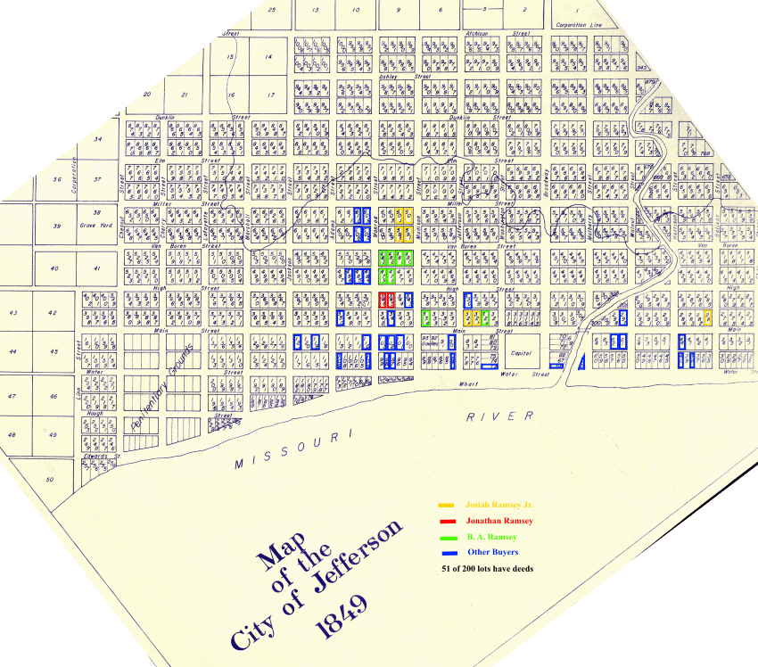
Link to simplified plat map of Jefferson City 1849
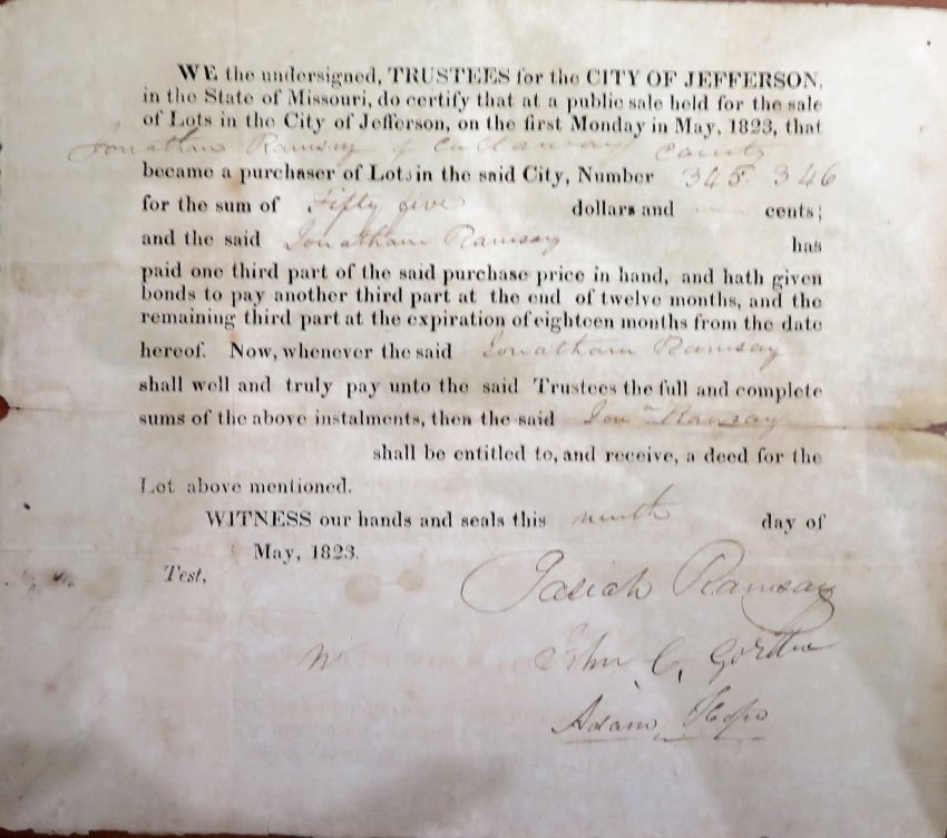
The following is a list of the copies of deeds from the May 1823 first sale of lots in the City of Jefferson that are on file in the Missouri State Archives.
Deed for Jonathan Ramsey purchase of two inlots
Location of 51 of the 200 lots sold in May 1823
Location of the Permanent Seat of Government - Perry S. Rader