|
 |
Early Jefferson City |
Early Jefferson City
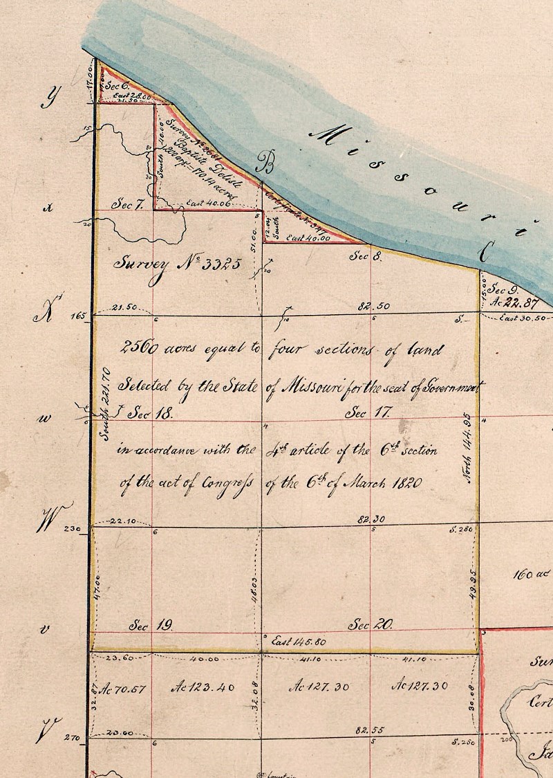
Jefferson City, originally known as "City of Jefferson", owes its' existence an act in the U. S. Legislature which set aside four sections (four square miles of land) to be used for the first capitol city of the State of Missouri, the first state west of the Mississippi River in the territory known as the Louisiana Purchase. . In accordance with the acts of the Sixteenth Congress of the United States, Session One, Chapter 22, Section 6, Article 4, enacted March 06, 1820, 2560 acres, equal to four sections of land (four square miles) which was selected by the soon to be State of Missouri for a city to be the seat of government (link to federal statute). These are denoted as Survey 3325, to include the Delisle Survey 2681. The directive for the determination of the location of the City of Jefferson was also defined int the 1820 Missouri Constitution, Article XI. (Zoomable document)
ACTS OF THE SIXTEENTH CONGRESS, STATUTE I, Chapter XXII, Section 6, Provision 4.
That four entire sections of land be, and the same are hereby, granted
to the said state, for the purpose of fixing their seat of government thereon; which said sections shall, under the direction of the legislature of said state, be located, as near as may be, in one body, at any time, in such townships and ranges as the legislature aforesaid may select, on any of the public lands of the United States: Provided, That such locations shall be made prior to the public sale of the lands surrounding such location.
APPROVED, March 6, 1820
REVISED STATUTES OF MISSOURI, Chapter 351, SEAT OF GOVERNMENT
1. The four sections of land situate on the south side of the Missouri River, in fractional township forty-four north, in range eleven west of the fifth principal meridian, to wit: the fractonal sections six, seven and eight; the entire sections seventeen and eighteen, and so much of the north part of sections nineteen and twenty, as will make up the entire for sections, selected by the commissioners on behalf of the state, according to the provisions of the constitution, and in persuance of an act of congress, approved the sixth day of March, one thousand eight hundred and twenty, be, and the same are hereby accepted for the use and benefit of the state.
2. the permanent seat of government of this state shall be located upon the said four sections of land accepted as aforsaid, and a town shall be laid out thereon, and the lots sold in such manner as shall be prescribed by law.
3. It shall be the duty of the governor to transmit an authenticated copy of this act, immediately after the passage thereof, to the surveyor of the United States for the states of Illinois and Missouri, and territory of Arkansas.
Approved December 31, 1821
(link to Seat of Government Statutes of Missouri)
The following map presents the full fractional township in which the four full sections of land were granted to Missouri for Permanent Seat of Government

The following map presents the four full sections of land granted to Missouri for Permanent Seat of Government
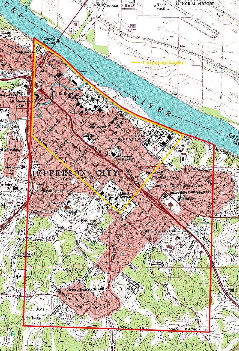
Those original boundaries as granted to the State of Missouri for the Capitol city translate to the following lines as displayed in bright red on a contemporary USGS Topographic map.
After all of the political wrangling, get rich schemes and insider information purchases which had an impact on the selection of the site for the Permanent Seat of Government for the State of Missouri, to be called "City of Jefferson", the newly formed Missouri Legislature enacted legislation to make it a reality. On December 19, 1822, the legislature passed Revised Statute, Chapter 466, Seat of Government, which established a framework for which to provide for the sale of certain lots, and the building of a State House in the City of Jefferson, the permanent seat of government of this state.
REVISED STATUTES OF MISSOURI, Chapter 466, SEAT OF GOVERNMENT Full text of Chapter 466, Seat of Government
Be it enacted by the General Assembly of the State of Missouri, [as follows:]
1. Josiah Ramsey, junior, John C. Gordon, and Adam Hope, be and they are hereby appointed trustees of the said city of Jefferson, who shall continue in office until the end of the session of the next general assembly, and until their successors shall be appointed and qualified; and if the office of any, or all, of said trustees should in any manner become vacant, the governor of this state is hereby authorized and required to fill such vacancy.
2. It shall be the duty of the said trustees to offer for sale to the highest bidder, at the said city, on the first Monday in May next, two hundred lots in the said city, to be selected by them, for cash or auditor's warrants, and to require one third of the purchase money to be paid down, one third in twelve months, and the remaining one third in eighteen months, after the said day of sale; provided, that if the whole of said lots are not sold on the day above mentioned, the sale may be continued from day to day until the whole are sold.
[ed. note - other provisions follow.]
Recap of Legislation for "Seat of Government"
(Revised Statutes of Missouri, RSMO 264 through RSMO 466)
Provisions of the Act Admitting Missouri as a State
(Missouri Compromise of 1820) As passed by U.S. Legislature on March 6, 1820
The original corporate limits of the City of Jefferson.
From the northwest corner beginning at the intersection of the range line between Township 44N Range 11W and Township 44N Range 12W with the Missouri River. The line of corporate limits then follows the river's edge in a southeasterly direction until it intersects the centerline of Linn Street on the east. The line of corporate limits then follows the centerline of Linn Street in a southwesterly direction until it intersects the centerline of Atchison Street. From that point, the line of corporate limits follows the centerline of Atchison Street in a northwesterly direction until it intersects the original range line between Township 44N Range 11W and Township 44N Range 12W at a point immediately east of Walnut Street. From this point, the line of corporate limits proceeds due north along that range line for eight blocks until it returns to the original point of origin. [ed. note - The original corporate limits may be seen on the 1849 Map of the City of Jefferson which is found in the Historic Maps section below.]
Historic Maps of Jefferson City
Sale of Lots Financed In Part the Building In 1824 of the First State Capitol
Newspaper Yellowed by Age Owned by Richard Fowler Gives Details of Report by Trustees Josiah Ramsey, Jr., John C. Gordon and Adam Hope
By N. A. BEDSWORTH
Missouri's first statehouse in Jefferson City was erected at a contract price of $24,739 in 1824 and 1825 on the site where the Executive Mansion now stands.
Back in those pioneering days expenditures were greater than receipts and as equally difficult to meet, as far as the trustees of the City of Jefferson were concerned, even as expenses in the operation of the state government today far exceed the revenue.
These trustees, Josiah Ramsey, Jr., John C. Gordon and Adam Hope, were designated and authorized by an act approved December 19, 1822, by one of the Missouri legislatures assembled in St. Louis to" supervise the sale of certain lots and the building of a state house in the city of Jefferson", the permanent seat, of government of this state. (The first commissioners were no strangers.)
How part of the financing of the building of the first capitol here, to whom the contract was awarded, and other interesting phases of the original foundations of the capitol of Missouri is outlined in a report of the commissioners to the General Assembly in 1824.
This report is contained in a newspaper account, yellowed with age, owned by Richard Fowler, present engineer of Jefferson City, and may be found in the original in the archives of the Missouri Historical Society at Columbia. The newspaper account was the property of Miss Elva Fowler, sister of the city engineer, now deceased.
The report, shows the quaint style of expression then in common vogue and gives great care to details in the sale of lots, the land of which was given to the young state by the federal government to establish its permanent seat, all is accounted for by the trustees down to half a cent. Following is the report in full:
"To the Honorable, the General Assembly of the State of Missouri:"
"In obedience to the provisions of the fourteenth section of an act of the General Assembly of this state entitled "An Act to Provide for the Sale of Certain Lots and Buildings of a State House in the City of Jefferson, the permanent seat of government of this state", approved the 19th December 1822, the undersigned trustees to said city beg to leave to report that they caused an advertisement to be inserted in four newspapers printed in this state giving notice of the sale of lots and the building of a state house, which advertisement will be seen by a reference to the fourth page of the "Missouri Intelligencer" herewith sent, also the "Missouri Republican", fourth page.
The trustees were not able to effect the removal of the New Madrid claim, as contemplated in the ninth section of the four recited acts; but on the day of the sale of lots to this place, Major A.L. Langham, attended as one of the proprietors of said claim, and by virtue of a power of attorney from other persons said to be claimants, also voluntary on his part, made a deed to the state for certain parts of said claim, which will more fully appear by reference to the deed, where it will seem that the second series of lots mentioned in said deed, beginning at lot number 45 and ending at lot number 113, both inclusive and also including the capitol square in the eight squares selected by the trustees, agreeably to the provisions to the tenth section of the before recited act, in addition to those lots, the proprietors deeded to the state, fifty-six other lots, being the first series of lots mentioned in said deed; although the powers of the trustees had expired as regards to the New Madrid claim, they conceived it to be their duty to have said deed and power of attorney recorded in the proper office, which they did and herewith send, marked A and B. [ed. note - Lots # 45 thru # 113 referred to above are bounded by Harrison St. on the west, Adams St. on the east, Water St. on the north and Main St. (Capitol Ave.) on the south. This includes the square dedicated to the original 1826 capitol and the second 1847 capitol.]

Sale of Lots
The trustees caused 200 lots selected by them, to be offered for sale to the highest bidder; the aggregate amount of which was $6,540.75; but to bring the matter plainly before your honorable body, it is thought most advisable to make out an account which will show at one view the receipts and expenditures which is as follows:
Amount of sales of lots, $6,540.75, out of which the following payments have been made to wit:
To the undertaker of the state house-
First receipt, marked 1, $2,185.25;
Second receipt, marked 2, $2,180.25;
Third receipt, marked 3, $1,722.32 & ½;
Fourth receipt, marked 4, $83.58 & ¼;
John Harrison, receipt marked 5, $2.00;
John Gordon, receipt marked 6, $5.00;
Edward Charles, receipt marked 7, $17.50;
Peter Bass, receipt marked 8, $1.50;
A.G. Bennett, receipt marked 9, $1.50;
Patton & Cleveland, receipt marked 10, $33.00;
Bonds not collected, $357.84;
Fee paid R.A. Ewing, receipt marked 11, $10.00;
(note: no receipt 12) ;
Henry Moss, receipt marked 13, $0.75;
Total $6,595.49 & ½.
The receipts for the foregoing payments is herewith sent, from number 1 to 13 inclusive.
By this statement it will appear that the trustees have paid out $54.74 & ½, more than the amount of the sales. The way that this sum accumulated was by the number of warrants paid in by persons who required no calculation of the interest then due them, and interest and interest accruing while the warrants were in the hands of the trustees, all of which was counted when paid out to the undertaker of the public building. The trustees were well aware that they were not bound by law to render any account of this sum; but believing themselves to be the agents of the state, they conceived it to be their duty to account for all money coming into their hands, as such they have done so accordingly.
Josiah Ramsey, Jr.;
John C. Gordon;
Adam Hope
City of Jefferson, November 07, 1824
Capitol Contracts
On the day of the sale of lots, the trustees let out to the lowest bidder, the building the House contemplated in the act under which they acted. Daniel Colgan, Jr., was the lowest bidder, at the sum of $24,739. A copy of his bond and a plan and a bill of the house is herewith sent, marked C. The building is now up and covered in, and was superintended by some of the trustees from the commencement till this time, in order that the materials and work could be in all respects conformable to the agreement entered into; and the trustees flatter themselves the work so far as it has progressed and will be calculated to give general satisfaction and they feel entirely confident that it will be completed by the time agreed upon. The trustees in common with their fellow citizens have to regret that at the time that this building was let out the funds of the state were so much below par that work could not be got done for a price, it could be got done for cash; indeed, in the article of printing, if paid in warrants, the charge was generally doubled.
The trustees thought it most expedient to have blank bonds and certificates for the purchasers of lots printed. A copy of each is herewith sent, marked D and E. They have paid off all of the printing accounts except for the editor of the Inquirer and Patriot, who have not yet forwarded their accounts, although requested to do so. (See copy of letter marked F).
"It was thought necessary to have a. person cry the sale of the lots and state house, and to have some person act as clerk. For this purpose they employed Wyncoop Warner as cryer and Jesse F. Royston as clerk, and they agreed to run the risk of the general assembly allowing them some compensation for their services. The trustees employed a lady of this place to draw a plan of this city, which will at one view show your honorable body to say whether you will allow some small compensation for the trouble of making it out.
The trustees having, as they conceive, stated fully all such matters and all things relating to the City of Jefferson which the law seems to require, beg leave to make a few observations on other subjects.
In the first place, the spring, which does at present, and will, perhaps for a long time to come, supply the citizens with water, is in lots number 76, 77, 82 and 83, or at least so situated that the sale of either of these lots would, in all probability, endanger the public use of the spring. The trustees thought it their duty to reserve those lots from sale and believe that it would be good policy in the General Assembly, to prevent by law, their being sold. They would also suggest the propriety of the Legislature authorizing the full trustees of this place, (if any should be appointed), or some other person to lease out a ferry from the city across the Missouri, as it is now becoming an object.
They further beg leave to suggest the propriety of investing the future trustees of this place with more general powers as the police of the city. This place is populating considerably, in consequence of which it becomes necessary to do something to the streets, alleys etc., as well as many other subjects, too numerous to mention here. Perhaps it might be most advisable to pass a law giving the trustees of this place the usual powers given to the trustees of towns, with liberty for citizens of the city to elect their trustees. This, in our opinion, will be better calculated to give general satisfaction than any other method, and, it is a privilege enjoyed by all other towns and cities, we hope it will be extended this, and feel entirely confident that men can be got in this place, able to discharge any necessary duties as trustees without any future expense to the state.
The trustees further beg leave to suggest the propriety to strike from the plan of this city the fractional block of lots containing the following numbers: 162, 163, 164, 165, 166 and 167, the propriety of which can be seen by a reference to the plan of the said city.
If the law under which the present trustees acted, had authorized the sale of the two hundred lots, by fifty at a time we feel entirely satisfied that the sales would have been much more productive; but as the provisions of the act were, in all respects imperative, the trustees feel it was their duty, under the oath they have taken, to conform to its' provison, in every respect. All of which is respectfully reported.
Page 4- THE SUNDAY NEWS AND TRIBUNE Jefferson City, Mo., Sunday, November 5,1933
January 17, 1943, The Sunday News and Tribune from Jefferson City, Missouri · Page 6
Grandmother Ewing, being somewhat of an artist, was appointed by the aforesaid Commission to draw and paint a plat of the city, or rather the city which was to be. She ordered. a piece of white canvass, twenty by thirty feet square, to be sent to her by steamboat from St. Louis. This canvass was stretched upon a wooden frame and upon it grandmother drew a map of the laid out town. She painted Broadway red, the other north and south streets green, and the cross streets blue.
[Ed. note - Excerpt from an article by Janet Ewing, granddaughter of Jane (Ramsey) Ewing, niece of trustee Josiah Ramsey Jr.]
Fulton Telegraph, Fulton, Mo., Friday Morning, July 14, 1876 - Page 4 REVISED STATUTES OF MISSOURI, Chapter 019, SEAT OF GOVERNMENT (1825)
So that the titles from the State to our lots are clear and indefeasible, the commissioners were instructed to lay off the town into 1,000 lots, the principal street to be not less than 100, or more than 120 feet wide, and the alleys to be 20 feet wide. On the 19th of December 1822, the first trustees of the city of Jefferson were appointed. They were Josiah Ramsay, Adam Hope and John C. Gordon, who were authorized to sell 200 lots. Four squares were reserved for a State House; one for a Governor's house; one for a hospital, and one for a seminary of learning. The first sale of lots occurred in May, 1823. At that tiem (1823) there were only two families living here. Those of Josiah Ramsey and Wm. Jones.
In 1825 the State House must have been nearly finished, for in February 08th of that year, the legislature appropriated $18,573 to pay Jas. Dunnica and Daniel Colgan for its erection. On the same day an appropriation was made to pay one of our most distinguished and estimable ladies, who, I hope is one of my audience. The act reads "To Mrs. Jane Ewing, for drawing and painting a plat of the city of Jefferson, the sum of $10." This product of the skill of this lady was unfortunately burnt in 1837, when the Capitol was consumed. To her numerous descendants the preservation and posession of that map could not be purchased for ten times the sum that whe received for it.
[Ed. note - An Extract from a Historical Address Delivered by Gen. James L. Minor, in the Hall of the House of Representatives, at Jefferson City, Mo., July 04, 1876]
Jean Batiste DeLisle
The DeLisle family was one of the earliest in New Madrid. Eustache DeLisle and John Baptiste DeLisle came to New Madrid in 1795 from Detroit. They were brothers of the third wife of Francois LeSieur. It should be said that the family continued to reside in New Madrid and that many of its descendants are among the prominent and influential citizens of the county now. In 1808 John Baptiste DeLisle left New Madrid for a visit to his sister, Mrs. Gremar, who then lived in Vincennes, Indiana. This was about the beginning of the war with Great Britain, and DeLisle enlisted in the United States army and served through the war. He then settled in New York, where he married, but was deprived of all of his family during the great epidemic of cholera in 1839. He returned to Vincennes in 1841 and found his sister yet living.
Up to this time he had supposed that his brother, Eustache, and his sister, the wife of Francois LeSieur, had been killed in the earthquakes; he was informed by his sister, how ever, that his relatives in New Madrid were still living. He at once communicated with them, to their very great astonishment, for they had considered him to be dead; in fact, after his leaving New Madrid in 1808, a report had come back to the post of his death, and they had sold the land that had been granted to him, consisting of 160 arpens of land, for a very small sum. This land had then passed into the hands of the persons who speculated in the land grants after the time of the earthquake. The state of Missouri had given to the purchasers of the Delisle land the right to locate an equal amount of land at some other place in the state and they had located this claim on the Missouri river where the city of Jefferson City now is. This grant from the state included within it the capitol grounds. Now, when John Baptiste DeLisle received this information that the land which he had possessed had passed away from him in this manner and that the state had given to the purchasers of his land a valuable grant, he brought suit against the state of Missouri to have the title to the lands thus granted declared to be in him. After various trials, the case was finally appealed to the Supreme court of the United States. It continued in that court from 1844 to 1862. In that year the court rendered a decision denying the claim of DeLisle to the land.
The earthquakes resulted in an immediate loss of population throughout all of the region affected. Most people who could do so moved away at once. Those who remained were either the more determined and daring of the population or they were the poorest who could not afford to leave. The flourishing village of Little Prairie, which, in 1803, had a population of 103, almost entirely disappeared. Only a few families remained. Among them was Col. J. H. Walker, who was not frightened enough to leave. New Madrid suffered greatly in the same way, the population showing a great falling off shortly after the shocks. The same thing was true of the settlements and small villages all over the district.
"History of Southeast Missouri"
The DELISLE CLAIM.
In the DeLisle case, involving the question of title to a portion of the seat of government, a trial was had in the Circuit Court and a decision rendered in favor of the defendant, but a writ of error was taken to the Supreme Court, where, one judge not sitting, the decision of the Circuit Court was affirmed, the two remaining judges dividing in opinion. The case will probably be taken to the Supreme Court of the United States, and in that event, a further appropriation will be needed to pay counsel for managing the case at Washington City.
In 1842, a New Madrid property owner, who had been living in the east since the earthquakes, returned to Missouri and sold his land, which had been damaged by the 1811 earthquake like many others. The new land title holders discovered, when trying to redeem the land title for better land on the Missouri River, Jean Baptiste Delisle's name already had been used on land claims. A land speculator named Angus Langham, who was a major cause for Cote sans Dessein to be disqualified, was found to hold some land under that name in the Capital City. So, a suit was filed in the Cole County circuit court in 1846 against Thomas Lawson Price, who was the city's first mayor, seeking judgment that the title holders of Delisle's New Madrid lands were the rightful owners of the illegally obtained lots which became Jefferson City. Because the land had not been surveyed before the faulty claim was made, the circuit court ruled against the title holders. The state supreme court then upheld the circuit court's ruling. And finally, in 1852, the U.S. Supreme Court ruled DeLisle had no claim because he was unaware of the state's exchanging of land deeds following the disaster nor of the subsequent fraudulent use of the DeLisle name.
Relating to the Francois Lesieur lands and the Jean Baptiste Delisle land claim in New Madrid, Missouri; papers, 1835-1851
Proceedings of the DeLisle Claim, Journal of Missouri Senate 1848
Proceedings of the DeLisle Claim, Journal of Missouri Supreme Court 1848
[ed. note - refer to the earlier historic maps of the lands selected for the seat of government for location of the DeLisle tract of land outlined in red.
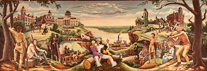
Centennial History of Jefferson City