|
 |
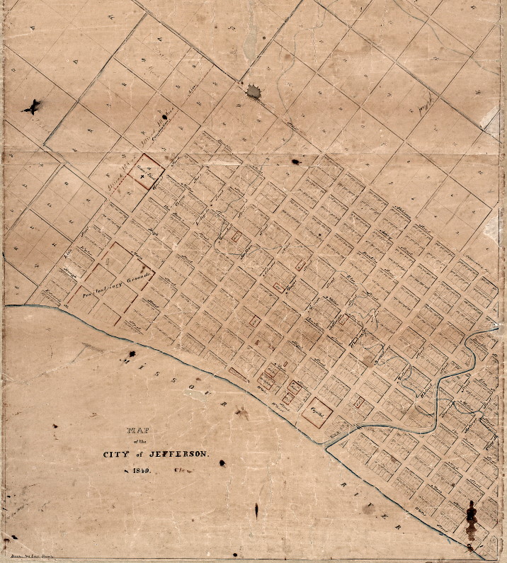
1849 Map of City of Jefferson |
1849 Map of City of Jefferson
The original map of the City of Jefferson, was produced by the surveyors and commissioners who laid out the city was destroyed in 1837 by the fire which consumed the Governor's Residence and the original meeting place of the Missouri Legislature. In its place, a map of the City of Jefferson, link below, created in 1849, is the only insight into way that the city was originally laid out and how the inlots and outlots were numbered. The 1849 map indicates which lots reserved for use by state and local interests and appear as outlined in red on that map. Those areas were not necessarily reserved at the time of the original platting in 1823, but were reserved by the time the replacement map was created in 1849. The list of reserved lots appear in the following listing.
                    1849 Map  -  Lots Withheld

Lots #              Purpose                         Location
38                  Graveyard                       McCarty (Van Buren) & Chestnut Streets
76 & 77             Spring                          Jefferson & Water Streets
82 & 83             Market                          NW Corner Capitol Avenue (Main) & Jefferson Streets
86 - 89             Old State House                 SW Corner Madison & Water Streets
92 & 93             Governor's Residence            NW Corner Madison & Capitol Avenue (Main) Streets
162 - 167           Water Street Lots               N of Water Street between Madison & Monroe Streets
311                 Catholic Church                 N Side High Street 2nd Lot W of Broadway Street
332                 Presbyterian Church             S Side Capitol Avenue (Main) between Madison & Jefferson Streets
351 & 352           County Court House              NE Corner High & Monroe Streets
388                 Spring                          S Side Water Street between Jefferson & Washington Streets
605 & 606           City Jail                       SE Corner McCarty (Van Buren) & Monroe Streets
627                 Jefferson School Commission     N Side Miller Street between Marshall & Jackson Streets
720                 Baptist Church                  SE Corner Miller & Monroe Streets
6 city blocks       Penitentiary                    Between Lafayette & Chestnut and Edwards & Capitol Avenue (Main)
1 city block        Capitol                         Between Water & Capitol Avenue (Main) and Washington & Broadway
Throughout the history of the City of Jefferson the 1849 map has been the accepted standard as the original organization of the way that the city was laid out and platted. This premise has been tested in local courts several times and has been upheld in all cases.
Click on the map image below to open a high resolution map of the city.


Communities
Cultural Resources
Historic Interest
Digital Newspaper Resources
Jefferson City Directories
MO Gazetteer & Business Dir
Local Yearbooks