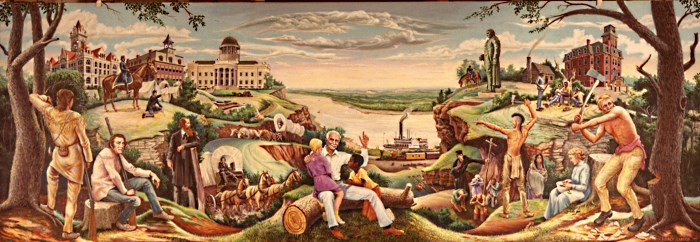
|
 |
Other Communities - Vintage Cole Photos |
Other Communities
Bass (38.43389,-92.32969)
Bass, was located near what is now called Old Bass Road near Hwy 54. In this location, there was a country store, Bass Mercantile, Co., established by the farmers in the community and named in honor of Mr. Metheldred Bass, a prominent farmer who owned the adjacent land. The store is now extinct. (E.L. Burch; J.E. Garman; Cited on Railroad Commission Map of Missouri, 1910) Source:Pace, Nadine. "Place Names In The Central Counties Of Missouri." M.A. thesis., University of Missouri-Columbia, 1928. The town of Bass could still be found in the 1930 plat book of Cole County (see picture on left). Bass is located approximately the corner of Old Bass Rd. and Oakland Rd.?? southwest of Brazito.
Bass, in Clark township, 16 miles southwest of Jefferson City and 5 from Russellville. the banking and shipping point. In the immediate vicinity of lead and zinc mines, some of which are worked to advantage. Mail daily. Population 35.
Bass Mercantile Co., general store.
Lopp. Dr., physician.
Scott, Byron, blacksmith.
Sheppert, E. D., photographer.
Burlington (38.70584,-92.35386)
Burlington
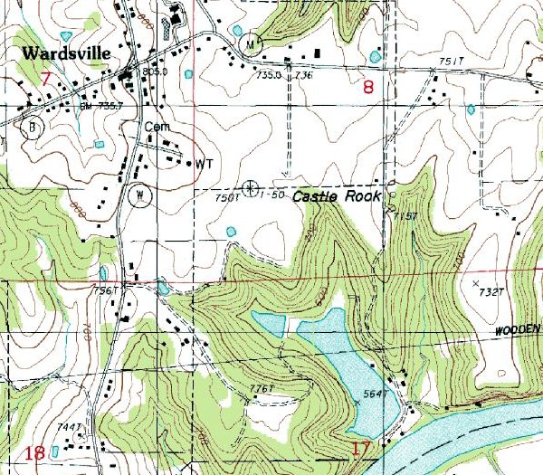
Castle Rock (38.48170,-92.16768)
Castle Rock, on the Osage bottoms at its main western bend in this county, was a beautiful site for a town; it was founded a few years before the Civil War, by the brave Col. George w. Boomer, of the Twenty-sixth Missouri Volunteer Infantry, who intended to make a representative place of it, and soon secured a large mill, a furniture factory, stores, hotel, church and school. At the outbreak of the Civil War it had assumed considerable proportions. His acceptance of the colonelship of "the brave little Twenty-sixth," and his fall in battle, was the signal for the ruin of his town, which fell as quickly as it rose.
Clark's Fork
Clark's Fork was located in Twp. 43 N, Range 13 West. (--Hist. of Cole Co., p. 204.) (Section is unknown.)
Clark's Fork is now in Cooper County. (--Rand, McNally, 1974.) Clark's Fork probably developed early in the southwest quarter of section 23 near what was called Clark's Ford in the 1919 Historic Atlas.
Cole Junction (38.61418,-92.22663)
Cole Junction (USGS-GNIS) Cole Junction was a railroad junction on the Missouri Pacific Railroad where the main line and the river route met. The name was given by the railroad company for the county. (J.C. Conrath; E.L. Burch; Cited on Railroad Commissioner's Map of Missouri, 1920) Source:Pace, Nadine. "Place Names In The Central Counties Of Missouri." M.A. thesis., University of Missouri-Columbia, 1928.
Gray's Creek
Gray's Creek was named by the pioneer, John Colgan, who lost an old gray mare in the fall and found her there in the spring in good condition. (Years were not given.) Hist. of Cole Co., p. 203.
John Colgan moved to Cole County in 1819. (--Hist. of Cole Co., p. 212.)
Haarville (38.506315,-92.072582)
An early name for Taos, Missouri. The site of the church of St. Francis Xavier in Taos was called Haarville, from the fact that it had been acquired from Henry Haar. By this name it was known for many years. The name was changed to Taos by Christopher and William Wagner who returned from the Mexican War. Their family also had land there .
Hickory Creek
Hickory Creek was platted by M. H. Belshe, on the east half of the S.W. 1/4 of S.E. 1/4 of Sec. 9, Twp. 42 N, Range 13 West, for John Lumpkin, and acknowledged by him December 14, 1867.
It is 21 miles south, southwest of Jefferson City, and had 1 school-house and 1 store. (--Gazetteer of Mo., p. 168.)
It is on Highway 54, northeast of Eldon (Miller Co.)
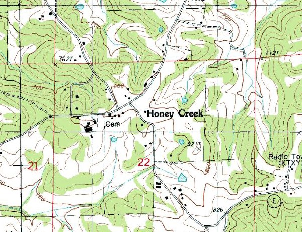
Honey Creek (38.46278,-92.24413)
Honey Creek is situated at Sec. 22, Twp. 43 N, Range 12 West on an unmarked county road north of E, west of the junction with B.
Mail via Jefferson City; no population shown. (--Rand, McNally, 1974.)
Indian Flats (38.36836,-92.21643)
St. Thomas's previous name, Indian Flats, that's what it was called on Fr. Helias' hand-drawn map that he used on his travels from one mission to another.
Moreau (38.55306,-92.34247)
Moreau
Payne Ford (38.46037,-92.45284)
Payne Ford (USGS-GNIS)
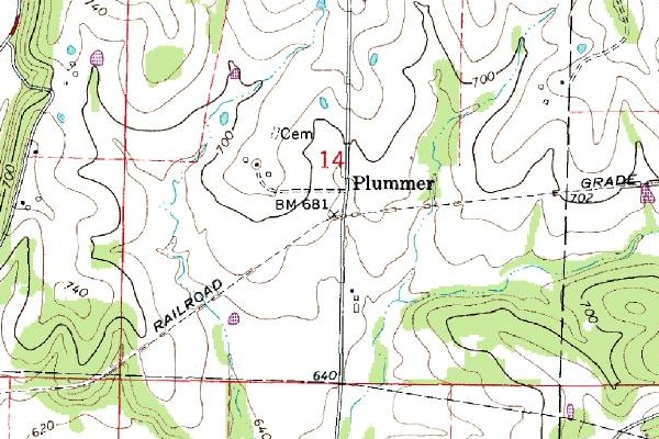
Plummer (38.56139,-92.33153)
Plummer was located between Scruggs and Lohman, on the Missouri Pacific R. R. (--Map of Mo., 1971, Thos. D. Murphy, Red Oak, IA.) Plummer sprang up on lands near the church and school in the southwest corner of section 11, Township 44N, Range 13W. The village was about a mile north of the southern branch of the Missouri Pacific Railroad Line.
Pratt's Mills
Pratt's Mills were eleven miles south of Centre Town. (--Hist. of Cole Co., p. 204.)
It is no longer listed.
Sacramento (38.525282,-92.0635829)
Sacramento
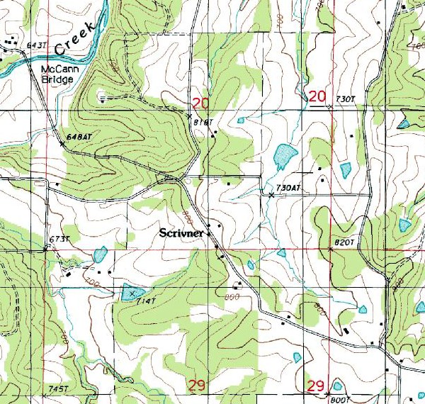
Scrivner (38.4547531,-92.3796291)
Scrivner was located in sections 14 and 23, Township 43N, Range 14W, approximately three miles south of Russellville. Latitude: 38.4547531N Longitude: 92.3796291W
Spring Valley (38.359580,-92.321358)
Spring Valley is a minor community at the intersection of Hwy BB with a county road about one mile north of Henley in sections 25 & 26, Township 42N, Range 13W, near Spring Valley School and Spring Valley Church.
St. Martins (38.594677,-92.336962)
St. Martins is situated at Sec. 3, Twp. 44 N, Range 13 West on Highway 50, west of T & D.
Mail via Jefferson City; population 50. (--Rand, McNally, 1974.)
Stringtown
Stringtown, on the southwest qr. of Sec. 21, Twp. 44 N, Range 13 West, was surveyed by W. Vogdt, and acknowledged by John and Andrew Blockberger, February 11, 1882. (--Hist. of Cole Co., p. 304.)
See Lohman.
Stringtown had 1 store. (--Gazetteer of Mo., p. 168.)
Stringtown is no longer listed in Cole County; Stringtown in Butler County. (--Rand McNally, 1974.)
Teal
Teal was southwest of St. Thomas, on Osage River. (--Sectional Map of Mo., 1894, Rand, McNally.) Section 32, Township 42N, Range 12W, between North & South Teal Bottom Roads.
Turner's Mill
Turner's Mill was on the Bois Brule. (--Hist. of Cole Co., p. 204.)
It is no longer listed.
Upper Jefferson
See Scott's Station. (--Gazetteer of Mo., p. 168.)
Whirlsville
Whirlsville was due south of Jefferson City. (--Sectional Map of Mo., 1894, Rand, McNally.)