|
 |
Schubert - Cole County Communities |

Schubert
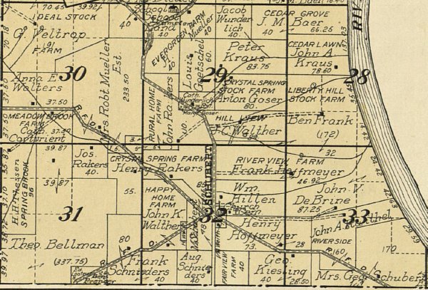
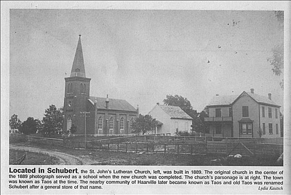
Schubert was situated at Sec. 32, Twp. 44 N, Range 10 West on Highway 63 south of Spur J.


Communities
Cole County 1914
Belleville
Brazito
Centertown
Decatur
Elston
Eugene
Ewing
Henley
Hickory Hill
Jefferson City
Lohman
Marion
McKinney
Millbrook
New Marion
Osage Bend
Osage Bluff
Osage City
Russellville
Schubert
Scotts
Scruggs
St. Thomas
Taos
Wardsville
Other Communities
Cultural Resources
Cole Communities (Moser)
Belleville
Brazito
Centertown
Decatur
Elston
Eugene
Ewing
Henley
Hickory Hill
Jefferson City
Lohman
Marion
McKinney
Millbrook
New Marion
Osage Bend
Osage Bluff
Osage City
Russellville
Schubert
Scotts
Scruggs
St. Thomas
Taos
Wardsville
Other Communities
Cultural Resources
Cole Communities (Moser)
Cultural Resources
Cultural Resources
1914 Cole Co. Plat Maps
1930 Cole Co. Plat Maps
Cole County Cemeteries
Cole Co. Cemeteries Map
Cole Co. Churches Map
Cole Co. Communities Map
Cole Co. Landmarks
Historic Schools of Cole County
Cole Co. Schools Map
Cole Co. Transportation
Cole Co. Points of Interest
Cole Co. Steamer Landings
Callaway Co. Cultural Resources
Historic Interest
HCJ's Newsletters
Jefferson City Landmarks
Bob Priddy's Blog
KRCG's Local History
Munichburg Memories
JC's Sanborn Maps
Show-Me The State
National Register Properties
Suden's Souvenir Booklet
Forest Drive Report
Forest Drive Survey
Munichburg Commercial District
Historic Southside Report
Historic Southside Survey
Historic Southside Map
Broadway-Dunklin Historic Distr
Historic East Report
Historic East Survey
Historic East Map
Moreau Drive Report
Moreau Drive Survey with Maps
Moreau Drive Map
State Capitol Historic Survey
Capital Historic District Report
Capital Historic District Survey
Capital Historic District Map
W. Main Historic Resources Surv
Sugarbaker Property
1913 JC Plat Map
1913 Trolley Route
1914 JC Historic Atlas
T44N R11W (Orig. Map)
T44N R11W (Amend. Map)
T44N R10W (Orig. Map)
T44N R10W (Amend. Map)
45N R12W (Amend. Map)
T45N R13W (Amend. Map)
T46N R13W (Amend. Map)
T45N & 46N R13W (Orig. Map)
Jefferson City Landmarks
Bob Priddy's Blog
KRCG's Local History
Munichburg Memories
JC's Sanborn Maps
Show-Me The State
National Register Properties
Suden's Souvenir Booklet
Historic District Reports
Capitol Ave. Historic DistrictForest Drive Report
Forest Drive Survey
Munichburg Commercial District
Historic Southside Report
Historic Southside Survey
Historic Southside Map
Broadway-Dunklin Historic Distr
Historic East Report
Historic East Survey
Historic East Map
Moreau Drive Report
Moreau Drive Survey with Maps
Moreau Drive Map
State Capitol Historic Survey
Capital Historic District Report
Capital Historic District Survey
Capital Historic District Map
W. Main Historic Resources Surv
Sugarbaker Property
Historic JC & Cole Co. Maps
1849 JC Plat Map1913 JC Plat Map
1913 Trolley Route
1914 JC Historic Atlas
T44N R11W (Orig. Map)
T44N R11W (Amend. Map)
T44N R10W (Orig. Map)
T44N R10W (Amend. Map)
45N R12W (Amend. Map)
T45N R13W (Amend. Map)
T46N R13W (Amend. Map)
T45N & 46N R13W (Orig. Map)
Digital Newspaper Resources
Jefferson City Directories
Jefferson City Directory – 1975
Jefferson City Directory – 1976
Jefferson City Directory – 1977
Jefferson City Directory – 1948
Jefferson City Directory – 52/53
Jefferson City Directory – 1959
Jefferson City Directory – 1967
Directory JC & Cole Co. - 1900
Directory JC & Cole Co. - 1900
Directories on LDS Genealogy
Jefferson City Directory – 1976
Jefferson City Directory – 1977
Jefferson City Directory – 1948
Jefferson City Directory – 52/53
Jefferson City Directory – 1959
Jefferson City Directory – 1967
Directory JC & Cole Co. - 1900
Directory JC & Cole Co. - 1900
Directories on LDS Genealogy
MO Gazetteer & Business Dir
Local Yearbooks
JC Marcullus 1938
JC Marcullus 1946
JC Marcullus 1947
JC Marcullus 1964
JC Marcullus 1965
JC Marcullus 1973
JC Marcullus 1974
JC Marcullus 1975
JC Marcullus 1976
St. Peters The Rock 1956
Helias Crusaders 1959
Helias Crusaders 1960
Helias Crusaders 1961
Helias Crusaders 1962
Fatima Sketchers 1962
Fatima Sketchers 1964
Lincoln Hilltop Echo 1952
Lincoln Hilltop Echo 1953
Lincoln Hilltop Echo 1954