|
 |
Public Land Survey System |
Public Land Survey System
1785 - The public land survey system was created by the United States Continental Congress’ Land Ordinance of 1785. To be able to make public lands available it was necessary to devise a way to divide a vast area into small uniform parcels that could be sold to individuals. The public land survey system provided a solution by dividing large swaths of land into 6 mile x 6 mile squares, called townships, and by dividing each township into thirty-six 1 mile x 1 mile squares, called sections. The public land survey system stacks the townships atop each other in a north-south direction, forming columns six miles wide. Each such column is called a range. With a system that clearly and regularly defined the limits of a parcel of land the deficiencies of the "metes and bounds" survey system could be overcome.
1803 - Louisiana Purchase from France doubled the size of the nation, adding the region drained by the Mississippi River's western tributaries. The vast region of uninhabited lands would lend itself well to the establishment of the Public Land Survey System. Before those lands could be sold to the American public it would be necessary to survey a region before public land sales could take place.
1812 - The General Land Office was created as part of the Treasury Department to handle and dispose of public lands. All the land records were now in one place. The British burned Washington, D.C. during the War of 1812. The General Land Office records were moved to a more fireproof building. At District Land Offices, tracts of surveyed public lands were sold at auctions to the highest bidder - at or above the minimum price set by Congress.
As early as 1812, settlers from the Kentucky Tennessee regions were beginning to move into the area of what would become the state of Missouri along the Missouri River. With the coming of the War of 1812 many of those early settlers withdrew from those lands to St. Charles and St. Louis because of the threat of Indian attack. Many of those settlers had faced the threat of Indian attack in Kentucky and were well aware of how to protect themselves and counter those attacks. Consequently, the appearanc of forts being established along the Missouri River basin to protect those settlers who remained.
1815 - Settlers begin to return to the eastern Missouri River basin region following the conclusion of the War of 1812 and find out that the General Land Office is not prepared to commence sales of public lands in the region. The first step in those surveys was to establish a base line, the 5th Principal Meridian, from which all subsequent surveys of a four state region were dependent.
The Fifth principal meridian is a principal meridian survey line used in the United States for land claims in the Public Land Survey System. It was first surveyed in 1815. The meridian, a north-south line, starts from the old mouth of the Arkansas River and runs north. Another survey line related to it is the base line running west from the old mouth of the St. Francis River. These survey lines govern all land surveys in four states and a large portion of the land surveys for two more.
On October 27, 1815, Deputy Surveyor Joseph C. Brown began the survey of the baseline at the confluence of the Mississippi and St. Francis Rivers and ran it due west. On the same date, Prospect C. Robbins began the survey of the meridian at the confluence of the Arkansas and Mississippi Rivers and ran it due north. On November 10,1815, at the intersection of those two survey lines was established the initial point of the Fifth Principal Meridian, which controls the rectangular surveys in all of Arkansas, Missouri, Iowa, North Dakota, and in most of Minnesota and half of South Dakota. Robbins' party continued north, on November 16, reaching the Missouri River on December 28, a distance of 317 miles, 35 chains and 76 links. The two lines run by these men, and the subsequent township and range lines surveyed from these lines, subdivided many hundreds of thousands acres of land. In the 1820s and into the 1850s, later surveyors crisscrossed the whole region, dividing it first into townships and then further dividing the townships into sections. By 1850 all of Missouri and northern Arkansas were subdivided.
1818 - Surveys of the eastern portion of the Missouri River basin and surrounding region had progressed to the point that land sales could be commenced from the St. Louis land office. Records of the abstract of land sales from that office indicate that sales of lands commenced on July 01, 1818. Sales of lands were made at auction of the lands, which would be held as the surveys progressed westward from St. Louis. The first evidence of a sale of land in either Cole or Callaway County occurred on November 20, 1818, for a 160 acre property to William Roads and a 140 acre property to Michael Allkier, both in eastern Callaway County. It wasn't until December 03, 1818, that any additional land sales in either county were made. As soon as it became apparent that lands in either of those counties was available those sales boomed. (see actual abstract)
Two additional land sales offices at Franklin in Howard County and Jackson in Cape Girardeau County opened on February 17, 1818. Information on all land sales offices may be found (here).
1820 - By 1820 sales of public lands boomed as more and more settlers migrated into the area to take advantage of low priced lands and military warrants and bounties. The Act of April 24, 1820, authorized land to be sold for a minimum of $1.25 per acre and tracts as small as 80 acres. Public lands initially offered for sale by District Land Offices were sold at pre-announced, scheduled public auction. If any land remained unsold, the parcels would be available for purchase at the minimum price on a first-come-first-served basis. This replaced the credit system. The President of the United States signed land patents, giving people title to the land. Hundreds, then thousands of Americans gave up their American nationality and chose to go under Mexican rule in order to get land in Texas for growing cotton. Auctions were held irregularly and sometimes lasted two weeks if enough prospective bidders attended. After an auction, unsold lands were available indefinitely at over-the-counter sales at minimum price.
The Public Land Survey System (PLSS) is the surveying method developed and used in the United States to plat, or divide, real property for sale and settling. Also known as the Rectangular Survey System, it was created by the Land Ordinance of 1785 to survey land ceded to the United States by the Treaty of Paris in 1783, following the end of the American Revolution. Beginning with the Seven Ranges in present-day Ohio, the PLSS has been used as the primary survey method in the United States. Following the passage of the Northwest Ordinance in 1787, the Surveyor General of the Northwest Territory platted lands in the Northwest Territory. The Surveyor General was later merged with the General Land Office, which later became a part of the U.S. Bureau of Land Management (BLM). Today, the BLM controls the survey, sale, and settling of lands acquired by the United States.
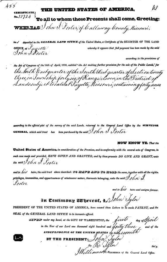
Sample apprearance copy of original patent image [readable and downloadable] available from BLM website. Search by Name, Township/Range, or Accession Number.
 |
In the Southern United States in the State-Land states, land is surveyed in the indescriminate metes and bounds system, not the federal township-range system. The metes and bounds survey system uses natural land features, such as trees and streams, as well as neighboring land owners, along with distances to describe plots of land.
For further discussion of Land Records in the United States, see Land and Tax Records by William Thorndale in The Source: A Guidebook of American Genealogy (1984) edited by Arlene Eakle and Johni Cerny, Ancestry, Inc., Salt Lake City, UT.
The Township-Range System is also described in most of the recent Plat Books of the counties in the Public Domain states, as well as many basic geology text books, such as Laboratory Manual for Physical Geology (1983) Sixth Edition, by Zumberge and Rutford, W.H. Brown Co., Dubuque, Iowa.
Terms used in the Township and Range System:
Section
Basic unit of the system, a square tract of line one mile by one mile containing 640 acres.
Township
36 sections ar ranged in a 6 by 6 array, measuring 6 miles by 6 miles. Sections are numbered beginning with the northeast-most section, proceeding west to 6, then south along the west edge of the township and to the east.
Range
Assigned to a township by measuring east or west of a Principal Meridian
Range Lines
North to south lines which mark township boundaries
Township Lines
East to west lines which mark township boundaries
Principal Meridian
Reference or beginning point for measuring east or west ranges.
Base line
Reference or beginning point for measuring north or south townships.
How the System Works.
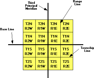
Graphical Display of the Federal Township and Range System
The largest grouping is the township which is named in reference to a Principal Meridian (P.M.) and a Baseline. T2N, R1E refers to Township 2 North (of the Baseline), Range 1 East (of the Principal Meridian).
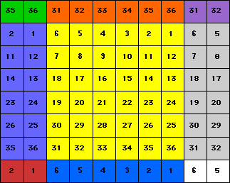
Within each township are 36 sections, each one mile square. Each section contains 640 acres. The sections are numbered from 1 to 36 in the following order. [Text only display]
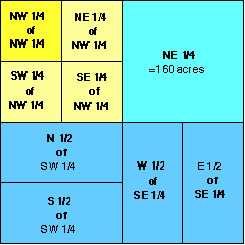
Within each section, the land is refered to as half and quarter sections. A one-sixteenth division is called a quarter of a quarter, as in the NW1/4 of the NW1/4. The descriptions are read from the smallest division to the largest.
A specific township is identified as being north or south of a particular baseline and east or west of a particular principal meridian. For example, T3N, R1E of the 3rd Principle Meridian is the third township north of the baseline in the first range east of the Third Principle Meridian. This particular 36 square-mile area is located in southern Illinois.
The land description generally starts with the smallest part of the description and proceeds to the largest definition. For example, SE1/4 of NW1/4 of Section 3, T3N, R1E, 3rd PM would be the southeast quarter of the northwest quarter of section 3 in township 3 north, range 2 east of the 3rd Principle Meridian.
You may find some irregularly shaped townships and sections which result from surveying errors and other difficulties.
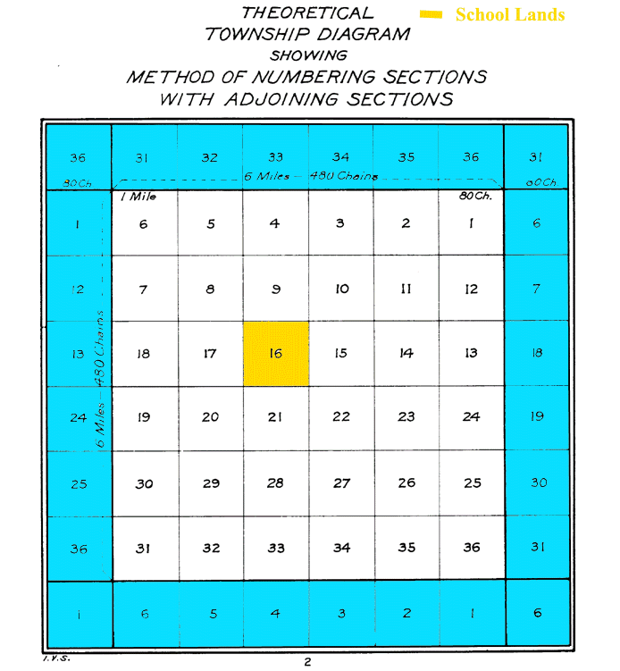
Under the 1785 act, section 16 of each township was set aside for school purposes and as such was often called the school section. Section 36 was also subsequently added as a school section in western states.[7] The various states and counties ignored, altered or amended this provision in their own ways, but the general (intended) effect was a guarantee that local schools would have an income and that the community schoolhouses would be centrally located for all children. An example of land allotments made specifically for higher education is Ohio's College Township.